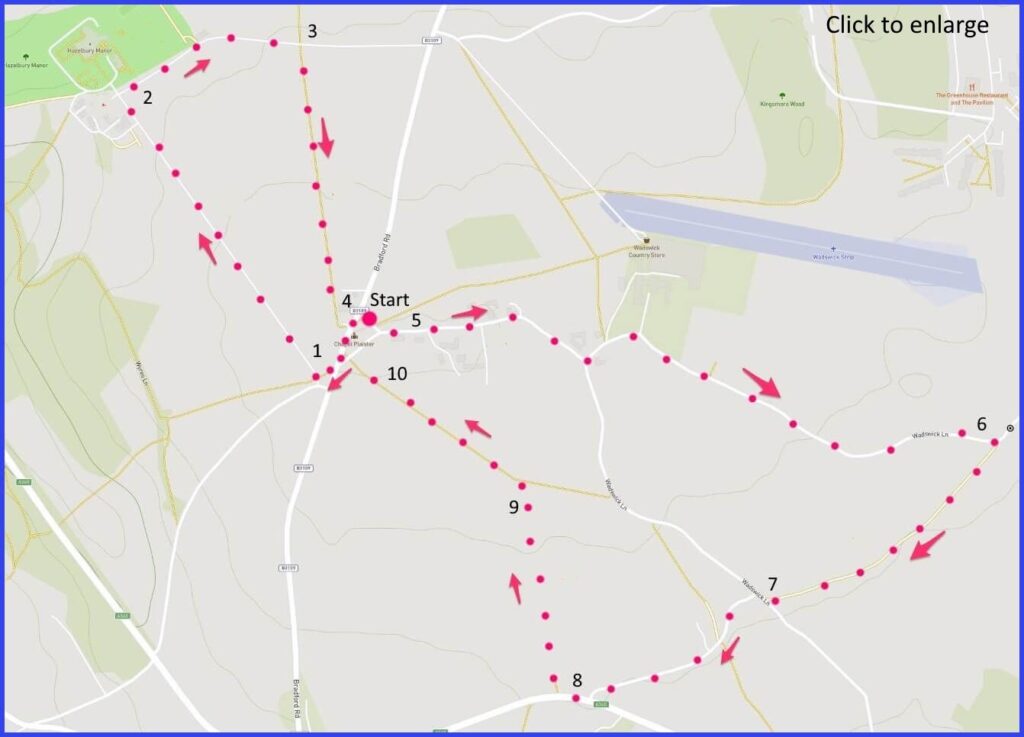
SN13 8HZ 3-mile level, quiet, figure-of-eight easy walk around Chapel Plaister: about a third of which on fields. Some mud – if wet. Click map to enlarge Water is blue, wooded green, contour lines show slopes. Click here for an aerial view. Click here to download/print PDF. (There is a GPX route option here for phone/tablet download. But only follow this link after watching this GPX help video). Friendly warning: all files relating to walks are published here on good faith but on the understanding that users must be responsible for their own safety and wellbeing.
(Routes from map points + metres to next point)
Start: On the left of main road there are a pair of right hand side turns that make a triangle with the chapel in the middle. Some parking possible here. Stand on main road and head left towards minor junction on opposite side. 125m
1 Turn left onto this small path. It leads to the signed entrance “Hazelburry Manor”. Walk long drive [A] to Manor. 620m
2 At the Manor, take a path on your right just before Manor gates. Path veers rightwards and entrance to field path appears on your right. 350m
3 Althhough on the left is a footpath sign, actually take the right into an open field [C] with a straight path towards dwellings opposite. 450m
4 There is a house just beyond which find a stile on the left. Then you are at your starting point. Cross road, walk past chapel and take lane at right angles to main road past houses. 150m
5 Continue to follow the lane [D], pass Manor Farm, pass solar farms on your left, past Wadswick Lane, continuing until you reach on a left turning bend the entrance to a signed field path on your right. 740m
6 Follow this path which half way becomes tree-lined, towards Wadswick Lane. 500m
7 Slight right and continue your direction on the path across Wadswick Lane. (Narrow in places) Until junction with main road (A365) Carefully walk a few metres to your right and enter a field path. 400m
8 Follow path forward to monument. 160m
9 At the stile first walk forward and then at field junction, walk diagonally towards a paddock area. 500m
10 To start. 100m
The pictures below are in the order things were seen on this walk. Clicking on any one will enlarge it (and the slideshow)
The walk
There is not much distraction from other people on this route, despite its proximity to the busy Bath Road (A4). Unfortunately, it follows that there are no refreshment points (or even a shop). Travellers do value refreshment of course and, as it happens, that was one purpose of the chapel (1235) that is the starting point for this walk. The route goes around the perimeter of a Manor house, then goes through the residential lane of the village, crosses a few fields, and returns to the start. It is an easy walk with few gradients.
Chapel Plaister village
It once served as a roadside haven for those on their various journeys. But then in earlier times the walking traveller would have been quite a common feature of the countryside. There were those that ‘rode’ of course, but then there were those that must walk. And not just ‘tramps’ resigned to their tramping: but peddlers, preachers, footpads, jobbing workmen, minstrels, messengers, and so on. All going about their pedestrian trades. Although after the 1671 Game Laws, many pedestrians risked being seen as potential poachers. It wasn’t until the 1770s that people (various poets and eccentrics) started walking for sheer pleasure. Or for protest. Samuel Coleridge’s walk from Cambridge to Wales was an act of solidarity with the labouring man. And yet… on this route in today’s safer times you are unlikely to see another person walking for (or from) their business – still less seeking Coleridge’s universal brotherhood.
However, the hospitality of this chapel may have been for those particular walkers with a more spiritual motive: namely those making their pilgrimage to Glastonbury (probably coming from Malmesbury). In later times (less pilgrim-sympathetic and more protestant) the chapel had to find a new function. Rather mundanely it became a beer storehouse for the Inn which used to be its neighbour (now a private house). Sadly, it doesn’t seem easy to visit the chapel – unless it’s a Wednesday, and the time is between 1400 and 1600 (and the month is between May and September).
The Manor
The walk proper starts by heading towards to the gates of Hazelbury Manor. And how strikingly straight and determined that approach is! The manor is a medieval site, but rebuilt in 1500 for John Bonham (no, not the Led Zeppelin drummer, but the 16th century Wiltshire politician), later occupied by the Speke family (more on descendants of which below) and then the ubiquitous Wiltshire Northey family from 1726.
How comfortably these great houses shift their identities. It was a farm for a long time, while from 1943 to 1971 the Manor served as a girls’ finishing school (rich with memories, so it seems). Pevsner says there is much of interest inside this building – but unless you catch one of the rare open days you won’t get the chance to confirm that – and then it’s likely to be only the gardens that are open (although they do look impressive as glimpsed on this walk through the thick protective boundary of trees). Right now it seems a tightly encased celebration of private wealth.
Wadswick Lane meanders past a number of tastefully rustic houses [D]. Beyond which there is some farming (including solar) but very little traffic. Not everyone welcomes solar farms. Apart from not being very beautiful, the Daily Mail tells us that they are full of noxious chemicals and made by Chinese prisoners. Fortunately, such stressful thoughts can be put aside, as most of the remaining walk (after routemap point 6) is then through open fields.
John Speke’ memorial
In addition to the Manor and the chapel refuge, the other significant point for reflection on this walk is at a stile in the penultimate field. Not an obvious place for a stone memorial [H]. It is there to honour the passing (at this spot) of John Hanning Speke (1827-64) the distinguished explorer – one walker whose journey did not end well. Speke was a rather prim aristocrat obsessed with shooting game. Whilst shooting birds in this field it seems he handled his gun carelessly at this very stile and shot himself instead. Sadly, he was dead before his companion could bring help.
The interest of the story is the possibility that it might have been suicide. The explorer Speke had become well known for his claim regarding the source of the Nile (Lake Victoria he (rightly) claimed). The explorer and author (“1001 Knights”) Richard Burton disagreed and their rivalry became toxic. The day after Speke’s death they were due to debate the Nile business in Bath. Burton claimed Speke’s death was not an accident but suicide – supposedly fearful of the demands of their debate. Many commentators think this is unlikely and simply a vindictive judgement from the far from amiable Burton. A sad and unexpected moment on a pleasant walk perhaps. Footnote: The full story of the desperate and dangerous Nile search that was independently carried out by these two is well told in Candice Millard’s book ‘River of the Gods‘


![[A]](https://wiltshirewalks.com/wp-content/uploads/2021/11/IMG_1173-150x150.jpg)
![[B]](https://wiltshirewalks.com/wp-content/uploads/2021/11/IMG_1175-150x150.jpg)
![[C]](https://wiltshirewalks.com/wp-content/uploads/2021/11/IMG_1176-150x150.jpg)
![[D]](https://wiltshirewalks.com/wp-content/uploads/2021/11/IMG_1177-150x150.jpg)
![[E]](https://wiltshirewalks.com/wp-content/uploads/2021/11/IMG_1179-150x150.jpg)
![[F]](https://wiltshirewalks.com/wp-content/uploads/2021/11/IMG_1180-150x150.jpg)
![[G]](https://wiltshirewalks.com/wp-content/uploads/2021/11/IMG_1181-150x150.jpg)
![[H]](https://wiltshirewalks.com/wp-content/uploads/2021/11/IMG_1182-150x150.jpg)