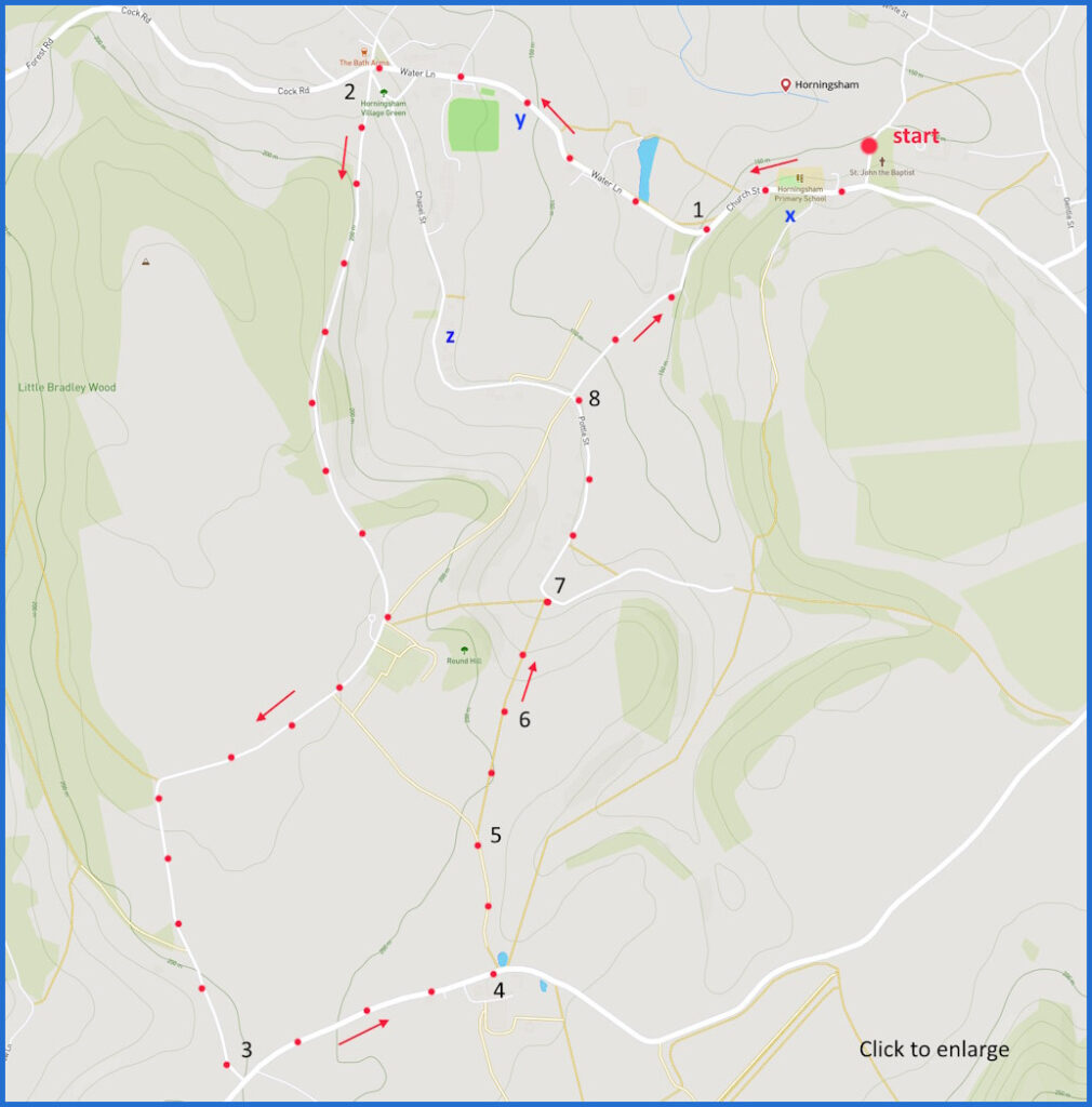
A 5-mile, easy, circular, walk from Horningsham on quiet lanes and some field. Click here for an aerial view. Click here for a downloadable PDF guide of this page. (There is a GPX route option here for phone/tablet download. But only follow this link after watching this GPX help video). Friendly warning: all files relating to walks are published here on good faith but on the understanding that users must be responsible for their own safety and wellbeing.
(Routes from map points + metres to next point) Blue dots are road-based alternative to fieldpath
Start: From here, walk up lane and right at main road until junction with war memorial 440m
1: Follow manicured paving up to major junction at Bath Arms 860m
2: Do not take road to chapel or main road, head down one in between 2.4Km
3: Turn left at junction with main road and walk to lefthand path opposite Baycliffe (pic here) 590m
4: Pick up path alongside pool, veer right to follow line of field walk to stile 3 00m
5: Walk diagonally across field towards stile 250m
6: Walk diagonally to exit on road 250m
7: Walk left and follow road to junction 470m
8: Follow on downhill towards war memorial at point 1 and then to start 870m
The pictures below are in the order things were seen on this walk. Clicking on any one will enlarge it (and the slideshow)
The walk
It is suggested here that you start at the parish church. If you drive here is just about possible to park on this cul de sac but if you prefer you could find a spot near the primary school (marked ‘x’ on the map) or by the village hall (‘y’ on the map). Walking starts along the well manicured Water Lane up towards the Bath Arms. Take the road by the red phone box and enjoy walking through the wooded valley. Very few cars on this road or the one that it junctions with. Take care at point 4 on the map, where a field walk starts. This photo guide may help take the best path: walk at the field edge first of all then follow a diagonal path across one field and then another. There are a couple of stiles to negotiate on this part 4-7.
The village
The church was founded in 1154 by the Norman Vernon family. Of what you see now the tower is 15th century but the rest of the building was reconstructed in 1844. The interior has been fairly Victorianised. The area is pleasingly quiet – at least it is outside of holiday season. In the summer it may pick up some of the visitors from nearby Longleat House. The walk at the start of point 2 is particularly pleasant.
Perhaps the most notable feature in the area is not on the route shown. But it is easily visited if you are prepared for a detour. Head down chapel street to point ‘z’ on the map and find the Congregational Chapel (or ‘Old Meeting House’). It could be the oldest dissenting chapel in the country (1566) – although there is no documentation of this and some people say its 17th century. The story goes that it was established for Scottish presbyterian workmen who were building John Thynne’s Longleat. The design inside and out certainly reflects the preference of dissenting groups for domestic architecture and the interior is lacking in the kind of ornamentation associated with Catholic worship – although, except for the gallery, it has been remodelled inside since that time.
You might like to complete your walk with a visit to the Bath Arms – a very good pub.


![[A]](https://wiltshirewalks.com/wp-content/uploads/2024/06/horningham01-150x150.jpg)
![[B]](https://wiltshirewalks.com/wp-content/uploads/2024/06/horningham02-150x150.jpg)
![[C]](https://wiltshirewalks.com/wp-content/uploads/2024/06/horningham04-150x150.jpg)
![[D]](https://wiltshirewalks.com/wp-content/uploads/2024/06/horningham03-150x150.jpg)
![[E]](https://wiltshirewalks.com/wp-content/uploads/2024/06/horningham05-150x150.jpg)
![[F]](https://wiltshirewalks.com/wp-content/uploads/2024/06/horningham06-150x150.jpg)
![[G]](https://wiltshirewalks.com/wp-content/uploads/2024/06/horningham07-150x150.jpg)
![[H]](https://wiltshirewalks.com/wp-content/uploads/2024/06/horningham08-150x150.jpg)