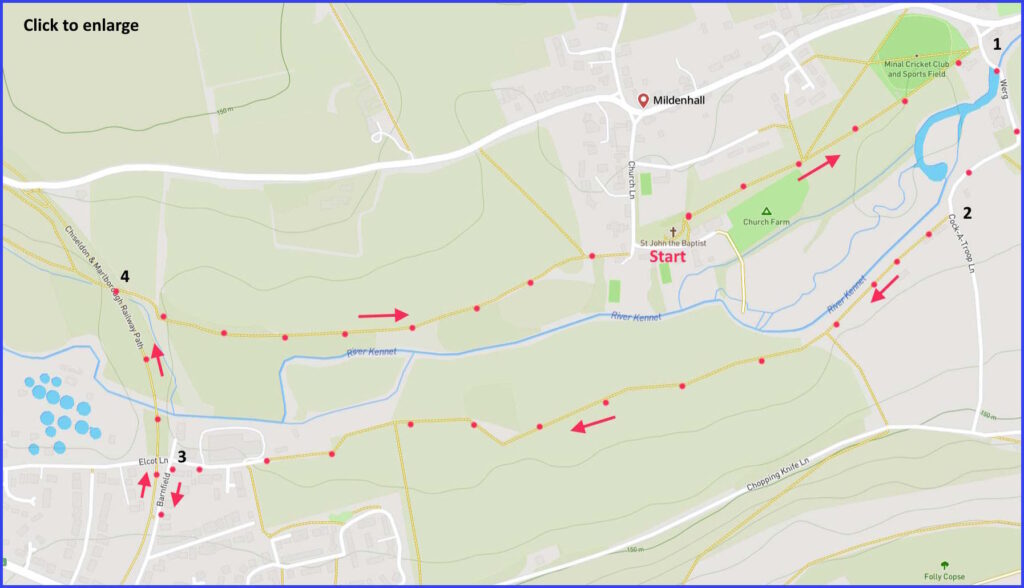
An easy 3-mile field walk alongside river Kennet. Suggest start from parking area set for church visitors. Click here for an aerial view. Click here for a downloadable PDF of guide. (There is a GPX route option here for phone/tablet download. But only follow this link after watching this GPX help video). Friendly warning: all files relating to walks are published here in good faith but on the understanding that users must be responsible for their own safety and wellbeing.
(Routes suggested from each map point + metres to next point)
Start: Exit churchyard at east; follow path through grazing field, then alongside sports field until road: 570m
1: Turn right, over river until path sign to Ecot and Werg: 320m
2: Take right past at this sign, forward through hedgerow and then large filed edge: 1.4Km
3: Just before overhead bridge, take left lane uphill to cut on right into old railway. Follow line to right, over river, until downward steps [H] on right: 480m
4: Follow field path towards starting point: 850m
The pictures below are in the order things were seen on this walk. Clicking on any one will enlarge it (and the slideshow)
This walk starts at the parish church (which has a helpful car parking area for visitors). Then the route runs through two fields beyond the churchyard, then takes you to a crossing over the River Kennet [B] with – to your left – the area of a Roman settlement. After walking parallel to the river, [F] you pick up a disused railway (now cycle) path to cross the Kennet and take a river-parallel route back to the church. (You may like to conclude at the Horseshoe Inn on the main road.)
Mildenhall village
The village lies on an alluvial plain, with the Marlborough Downs to the North and Savernake Forest to the South. Through this valley runs the River Kennet.
It seems this area was occupied since the iron age. But in more recent times it was the site of a large Roman settlement (see more on this below). Then, after the Roman departure, the area continued to support an Anglo-Saxon community. With the Doomsday Book reporting 20 households. It has always been a farming area, with extensive sheep farming in the 14th century – dominated by the Hungerford estates.
The present village layout indicates a traditional gathering of dwellings around the parish church and Church Lane, but then a larger development around the main road. A recent survey has claimed that all this has made Mildenhall one of Wiltshire’s five “poshest villages” to live in. Estate agents need to amuse themselves this way – you can perhaps use the walk to make your own mind up. However, the village’s online presence does at least suggest a lively community, whether or not it is also a ‘posh’ one.
The church
There may have been a church here since the 9th century. The present parish church of St John the Baptist is described by Pevsner as “a perfect example of the small village church of many periods, exceptional for its late Georgian furnishings”. That fine interior furnishing was the result of a refit around1815. As well as the box and family pews, don’t miss the “children’s benches” at the west end of the nave. Although arranging two group of small children in rows facing each other and away from the main action would surely have been a recipe for mayhem? And notice the unusually paired and adjacent pulpits (surely not for debates?).
In 1978 the Revd. Courtman here was the oldest vicar in the country (94). Although he is best remembered for his achievement in making official the spelling of “Minal” – which is the name for Mildenhall that has long been preferred informally in the talk of locals.
Cunetio
A little distance after you cross the river near the start of this walk [B], the fields to your left are the site of what was once a large Roman settlement: Cunetio. It seems the area was a full walled Roman town, at least until the 5th century. Although it was only discovered quite recently (in the 1940s) and then as a result of clever aerial photography. So any sign of this once sizeable community will not be visible now – at least not to the untrained eye. Cunetio was most likely an important trading area, as it would have been a junction point for significant roads that once variously joined London, Bath, Winchester and Cirencester.
An account of excavations at this site can be found here. Although a more detailed story of this work is covered by a TV documentary in an episode of the Time Team series. The Romans had a habit of burying large quantities of coinage (there are many accounts of why they did this – for example this one). Accordingly, in 1978 a hoard of 54,951 such coins were found at this site – variously dated between AD 260 and 275 and now residing in the British Museum as the ‘Mildenhall Hoard’. But don’t be tempted to start your own proving around for more relics – while such searching might not be uncommon, it would be unwise and unwelcome..


![[A]](https://wiltshirewalks.com/wp-content/uploads/2023/05/mildenhall01-150x150.jpg)
![[B]](https://wiltshirewalks.com/wp-content/uploads/2023/05/mildenhall02-150x150.jpg)
![[C]](https://wiltshirewalks.com/wp-content/uploads/2023/05/mildenhall03-150x150.jpg)
![[D]](https://wiltshirewalks.com/wp-content/uploads/2023/05/mildenhall04-1-150x150.jpg)
![[E]](https://wiltshirewalks.com/wp-content/uploads/2023/05/mildenhall05-150x150.jpg)
![[F]](https://wiltshirewalks.com/wp-content/uploads/2023/05/mildenhall06-150x150.jpg)
![[G]](https://wiltshirewalks.com/wp-content/uploads/2023/05/mildenhall07-150x150.jpg)
![[H]](https://wiltshirewalks.com/wp-content/uploads/2023/05/mildenhall08-150x150.jpg)
![[I]](https://wiltshirewalks.com/wp-content/uploads/2023/05/mildenhall09-150x150.jpg)