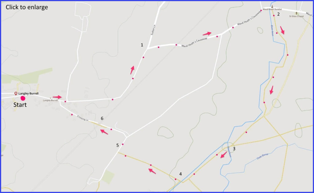
SN15 4LQ where there is roadside parking. This is a 2.5 mile circular flat walk around Langley Burrell, along a famous route; some field paths. Click map to enlarge. Click here for an aerial view. Click here to download/print PDF. (There is a GPX route option here for phone/tablet download. But only follow this link after watching this GPX help video). Friendly warning: all files relating to walks are published here on good faith but on the understanding that users must be responsible for their own safety and wellbeing.
(Routes from map points + metres to next point)
Start: Parking is possible opposite the pub. Turn right if exiting the pub and walk on Maid Causeway road to Y-junction. 740m
1 Continue on right fork at Y-junction towards Maud Heath Sundial and nearby church. 1km
2 There is a footpath entrance just beyond the church. From there you simply follow the Avon river bank. Walk forward until a river crossing where the Avon Y-splits. Cross the branch you have been on. 1km
3 Walk forward across straight bank of the Avon. 340m
4 A path along edge of field takes you to a lane junction. 400m
5 Turn right towards a Y-junction on this lane. Taking sharp left turn towards railway. 270m
6 Take a footbridge over the railway line. Continue back to causeway and to the Langley Tap pub. 330m
The pictures below are in the order things were seen on this walk. Clicking on any one will enlarge it (and the slideshow)
The walk
A walk anchored to some place of human settlement is always more rewarding if stories can be attached to that place. In the case of this village, the main story is the causeway – which is the route for the first part of this walk. However, there is other history that colours in the identity of this small settlement just outside of Chippenham. Park near the pub and follow the pavement route towards the causeway. From there a few fields are crossed that lead, in a straightforward way, back to the starting point.
About Maud Heath
The suggested walk starts at the Langley Tap pub (where parking on the road opposite is usually possible). Maud Heath was a resident of this village until her death in 1474. Maud left no will but did bequeath all her savings and estate to trustees. Their responsibilities were to build and maintain a 4.5 mile causeway from Wick Hill to Chippenham. It runs through Langley Burrell. Cobble stones that were part of the original ‘Maud Heath Causeway’ are still visible on early sections of this route [A].
Legend has it that Maud was a local working woman who had struggled on this walk when carrying her fragile eggs and butter to Chippenham market. So, the purpose of her legacy was to make this swampy route more manageable for other poor souls. The reality is that Maud was probably of higher status than a market girl, because her estate must have been fairly substantial (bequeathing eight pounds a year for ever). Moreover, 500 years later the charity is still maintaining the path. For example, when the railway bridge was built over this road, a dedicated arch was created for the causeway pedestrians (you wakk through it). More dramatically, and visible shortly after this bridge, the path was raised above the floodplain (pic 05) on a line of 64 brick arches (1812, although reconstructed more recently).
Close to these arches is a limestone monument (1698) that publicly acknowledged (for the first time) Maud’s bequest [B]. It would be possible for you to extend this walk eastwards and visit a more substantial Maud memorial: one erected in 1838 by the Third Marquis of Lansdowne and the local Reverend Bowles. This comprises a tall column with Maud perched on top – depicted in that favoured version of history which casts her as a simple market trader clutching a basket of goods. The column incorporates a celebratory poem (Pevsner comments “the quality of the poetry matches that of the statue”). In a storm of 1990 her statued form was beheaded; but, fortunately, the stricken part was recovered and replaced. If making a walking detour to see this column does not appeal, then an alternative might be this drone video (perhaps without the drone-like music)
Beyond the causeway
Just beyond the 64-arch wonder is the striking small church of St Giles [C], [D]. This building is from 1805, replacing a chapel attached to the nearby C17 and C18 Kellaways Mill (now a private house). Legend claims that this move was made necessary because the former building was overrun with rats (they disrupted services).
Thereafter the walk follows the flow of the Avon. One unexpected feature is a lone pillbox [I]. It would surely have been part of ‘Stop Line Green’ (SLG), which in turn was part of wartime GHQ (General Headquarters Line). Because the British Army had abandoned so much equipment at Dunkirk, there was a real concern over a possible German invasion. The GHQ therefore sectioned the country in such a pattern as to delay the enemy for long enough to organise resistance. SLG defended Bristol: allowing evacuation or resupply from the docks. This particular pillbox seems to be of type FW3/24 (hexagonal). The Stop Line Green of which it must be a part can be followed on this map – although it looks as if the current pillbox is marked slightly out of proper position.
The walk returns to the Langley Tap pub (next to an abandoned brewery, now offices for the National Farmers Union). The pub (at time of visiting) is excellent and so this destination should be very welcome.
Another local celebrity
However, the walk could be briefly extended (perhaps by car as the roadway walk is uninviting) in order to take in Langley Burrell’s St Peters church (“large and impressive” says Pevsner). It lies half a mile up the main road (B4069). The building is likely to be locked (firm warning notices and cameras) but it is “impressive” for its human history as well as its architecture. The diarist Francis Kilvert (1840-79) was born to the rector of Langley Burrell and was for two periods himself its curate here (1863-4 and 1872-6). Kilvert’s diaries of everyday rural life continue to have a keen following. They were dramatized as a 1977 television series of eighteen 15-minute episodes and John Betjeman also broadcast a TV documentary on Kilvert (‘Vicar of this parish’) . Finally, there is an audio reading series available on Radio 4. All this is doubless good for Langley Burrell … except that Kilvert’s story of rural life was initiated during his time working on the Welsh borders, not Wiltshire, and rather more is said about those times. Sadly, he was forced to retreat from the borders back to Langley, despondant because the father of his Welsh sweetheart had forbidden their marriage.
Next to the church is Langley House (sometimes known as ‘Ashe Manor’). Around 1655 this was purchased by Samuel Ashe and both church and house have long been associated with the Ashe family. The present house was built for the Rev. Robert Ashe in 1758. It has remained in the (now ‘Scott-Ashe’) family ever since. Langley Burrell is a well-preserved example of the tight binding of church, manor and family


![[A]](https://wiltshirewalks.com/wp-content/uploads/2021/12/Langley01-150x150.jpg)
![[B]](https://wiltshirewalks.com/wp-content/uploads/2021/12/langley02-150x150.jpg)
![[C]](https://wiltshirewalks.com/wp-content/uploads/2021/12/langley03-150x150.jpg)
![[D]](https://wiltshirewalks.com/wp-content/uploads/2021/12/langley04-150x150.jpg)
![[E]](https://wiltshirewalks.com/wp-content/uploads/2021/12/langley05-150x150.jpg)
![[F]](https://wiltshirewalks.com/wp-content/uploads/2021/12/langley06-150x150.jpg)
![[G]](https://wiltshirewalks.com/wp-content/uploads/2021/12/langley07-150x150.jpg)
![[H]](https://wiltshirewalks.com/wp-content/uploads/2021/12/langley08-150x150.jpg)
![[I]](https://wiltshirewalks.com/wp-content/uploads/2021/12/langley09-150x150.jpg)
![[J]](https://wiltshirewalks.com/wp-content/uploads/2021/12/langlehy10-150x150.jpg)