4 miles: walk around Easton Grey a cotswold village, hangout for Victorian intellectuals, original Fosse Way, Romans. Pretty flat, might be muddy – much field walking. Some tricky stiles. Click map to enlarge. Click here for arial view. Click here to download/print PDF. (There is a GPX route option here for phone/tablet download. But only follow this link after watching this GPX help video). Friendly warning: all files relating to walks are published here on good faith but on the understanding that users must be responsible for their own safety and wellbeing.
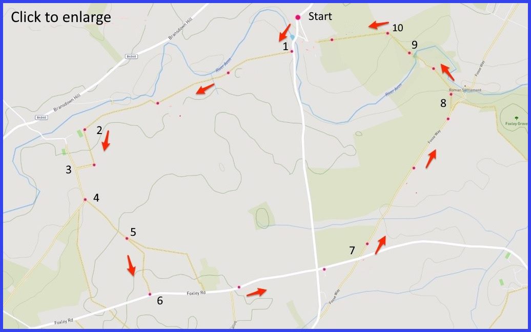
(Routes from map points + metres to next point)
Start: Parking is scarce here. You may find somewhere further up the hill down into the village. In which case you could take in the hidden church on left of the road down (pic [A]). Depending where parked, approx 400m
1 Cross village bridge [C] and, shortly after, find a footpath to enter field on right [D]. Parallel to river edge [F] walk towards wooded edge of field and continue following that straight-ish line, passing into a second field, and then a third. 1.2km
2 Sharp left in front of farm builidings, and up a fenced edge [H]. Turn right at the top of this path to the next junction. 340m
3 Walk to path next junction 200m
4 At this point the aim is to reach Foxley Rd (map point 6). The distance is short but maps show different route options. Official paths are not clearly marked but field edges can be followed. Our map suggests walking to next field boundary and cross then that field (generally veering rightwards and away from the woods behind you). 300m
5 At this large field space, walk rightwards diagonally towards road at corner of field. 340m
6 Turn right and walk up paved road. Continue over crossroads to join Fosse Way [J] (Turning left at these crossroads takes you back to the village an easier way). 1.2km
7 Take first left after the Foxley crossroads onto the Fosse Way. 1km
8 At (gate marked) site of Roman settlement veer left to follow that path towards River Avon crossing [closeup map here]. 300m
9 Don’t turn left at the abandoned stone building, carry straight to find bridge across Avon (hidden around corner but a solid structure) 200m
10 A this junction of 4 fields, orient left and take the path almost at right angles to your previous direction. This takes you across open field to a stile opposite (although use edges if footing is better). Aiming for farm buildings and village behind them. 380m
The pictures below are in the order things were seen on this walk. Clicking on any one will enlarge it (and the slideshow)

![[A]](https://wiltshirewalks.com/wp-content/uploads/2021/12/01easton.jpg)
![[B]](https://wiltshirewalks.com/wp-content/uploads/2021/12/02easton.jpg)
![[C]](https://wiltshirewalks.com/wp-content/uploads/2021/12/03easton.jpg)
![[D]](https://wiltshirewalks.com/wp-content/uploads/2021/12/04easton.jpg)
![[E]](https://wiltshirewalks.com/wp-content/uploads/2021/12/05easton.jpg)
![[F]](https://wiltshirewalks.com/wp-content/uploads/2021/12/06easton.jpg)
![[G]](https://wiltshirewalks.com/wp-content/uploads/2021/12/07easton.jpg)
![[H]](https://wiltshirewalks.com/wp-content/uploads/2021/12/08easton.jpg)
![[I]](https://wiltshirewalks.com/wp-content/uploads/2021/12/09easton.jpg)
![[J] Fosse Flytipping](https://wiltshirewalks.com/wp-content/uploads/2021/12/10easton.jpg)
![[K]](https://wiltshirewalks.com/wp-content/uploads/2021/12/11easton.jpg)
The walk
Parking is difficult in the village, so you may have to be creative in getting something further back on the entry road – although there is a small spot at a turning on the left going down The walking route is partly across fields followed by a section of paved road (little traffic) that leads to the route of the original Fosse Way. It is that final part (after a left direction turn at the Roman settlement) that requires a little vigilance in keeping to the official paths that lead back to the start. Make sure you cross the river, walk forward and veer left towards the village.
The village
A one-street Cotswold village, eerily silent, small stone cottages, clear river flowing under ancient bridge, Manor House with a story, charmed church, red telephone box – a picture book scene. Yet there is plenty of history behind this tranquillity. The walk starts in the village, crosses well farmed fields, goes up a track of the original Fosse Way, passes by a Roman settlement and then returns to village (no refreshment opportunities here).
You will find the church nestling in a wooded area at the top of the village hill. Most of it was built around 1836 but the tower at the west end is 15th century. Internal pleasures include a 13th century font, tiny Jacobean pulpit, Gothic organ, and rather severe box pews. A list of rectors [B] indicates the age of the parish. There is a path from the churchyard into the grounds of the Manor – this is tempting but odd, because keep in mind it is a private house.
A soulful manor
The walk starts by crossing the 16th century five-arch bridge over the River Avon. Shortly after entering the fields to the right there will be glimpses of Easton Grey Manor [E]. The present building dates from 1792, after an older building was knocked down. At the end of the Victorian era it belonged to the sister-in-law of prime minister Asquith. At which time it hosted meetings of “the Souls” (who tended to call themselves “the gang”), a group of politicians and intellectuals weary of London’s political tension (i.e., the Irish question), seeking to convene convivial, intellectual and artistic company elsewhere. Uncharacteristic of the time, women were key participants. They saw themselves as a contrast to the macho group associated with the Prince of Wales (Edward VIII). There are books about them: ‘The souls‘ and ‘Unquiet souls‘ although the community faded away early in the 20th century (many died in the Great War). A group called ‘The Coterie‘ briefly revived the spirit – it included a few offspring of The Souls.
Since then the Manor House has had a few changes of ownership and, subsequently, some degree of neglect, At least that is until the 1950s, when it was purchased on impulse by Peter Saunders, a fashion designer specialising in tweeds for the middle classes (Royal Weaver to the Queen). He cultivated the squire-archy style with some gusto (see him in his bathroom here). Enthusiasm even extended to writing a book about the Manor. His American wife (Didi) stayed in the house until her death in 1959. A very recent owner was Michael Green, the founder of Carlton TV. (However, as he has now retrained as a psychotherapist in London…this may no longer be the case).
The Romans here
There is significant British history locked into this area. Flint tool evidence has been found around Easton Grey, implying a neolithic settlement. Beyond that, an iron age community is believed to have existed – perhaps a satellite to the larger centre at nearby Malmsbury. It is thought that Dubunni coins found here must suggest a thriving pre-Roman settlement of some sort.
Then the walk offers a feel for a later (Roman) history of the area when you reach a section of the original Fosse Way – complete with modern fly tipping (pic J). This area lies on the longest of the Roman roads (Lincoln to Exeter), which may have served as a land frontier for Governor Plautius. It was built by men of the 14th legion although its splendid engineering has now become just a narrow track, and rather overgrown in this section of the walk. It is, of course, ruthlessly straight (Romans had no time for Nimbys).
These roads had servicing stations every 5 miles and staging posts every 15. Easton Grey (or at least the While Walls area around the marked ‘Roman site’) was probably one of the latter. Perhaps it was important because the area was at a major river crossing – and also was half way between Cirencester and Bath. Sadly, the ‘site of Roman settlement’ on this route has been badly damaged by rogue 4×4 off-road drivers. This is not an area that is easy to protect from modern enthusiasms.
By Domesday the settlement had become a small farming community (Estone), with a useful mill. The present village name is derived from this and the family of John de Grey (1265-1324) who owned the Manor with the estate: which thereafter passed among various familes – Stourton, Hodges, Adye, Parry and so on. The present cottages are engaging and well preserved, although one or two look like they may be hideways for merchant bankers.