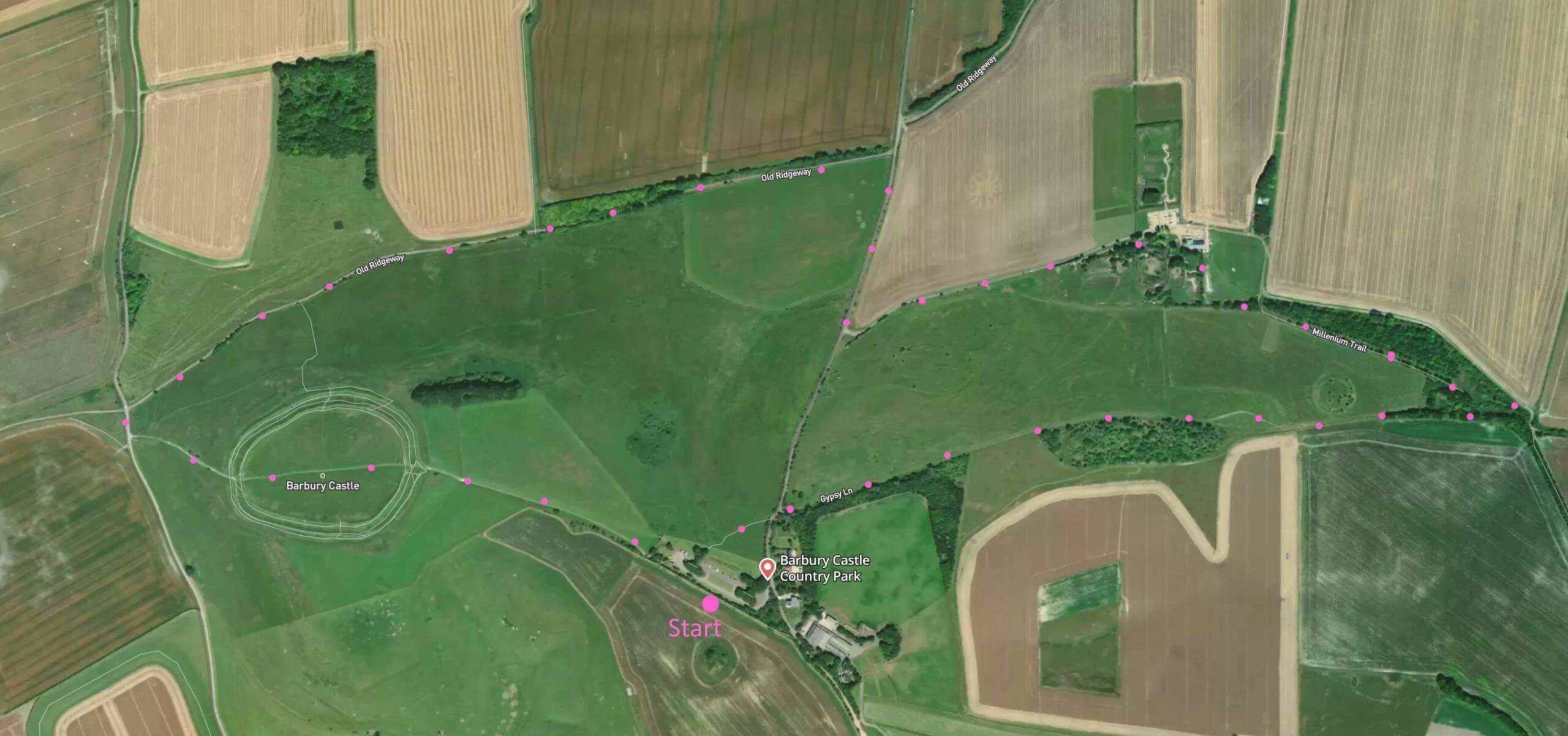
A 3-mile Wiltshire walk across a hill fort and then along the Old Ridgeway. Final part of the walk is quite steep – with a few stiles. Parking is free at Country Park (toilet facilities only). Click here for an aerial view. Click here for printable PDF download. (There is a GPX route option here for phone/tablet download. But only follow this link after watching this GPX help video). Friendly warning: all files relating to walks are published here on good faith but on the understanding that users must be responsible for their own safety and wellbeing.
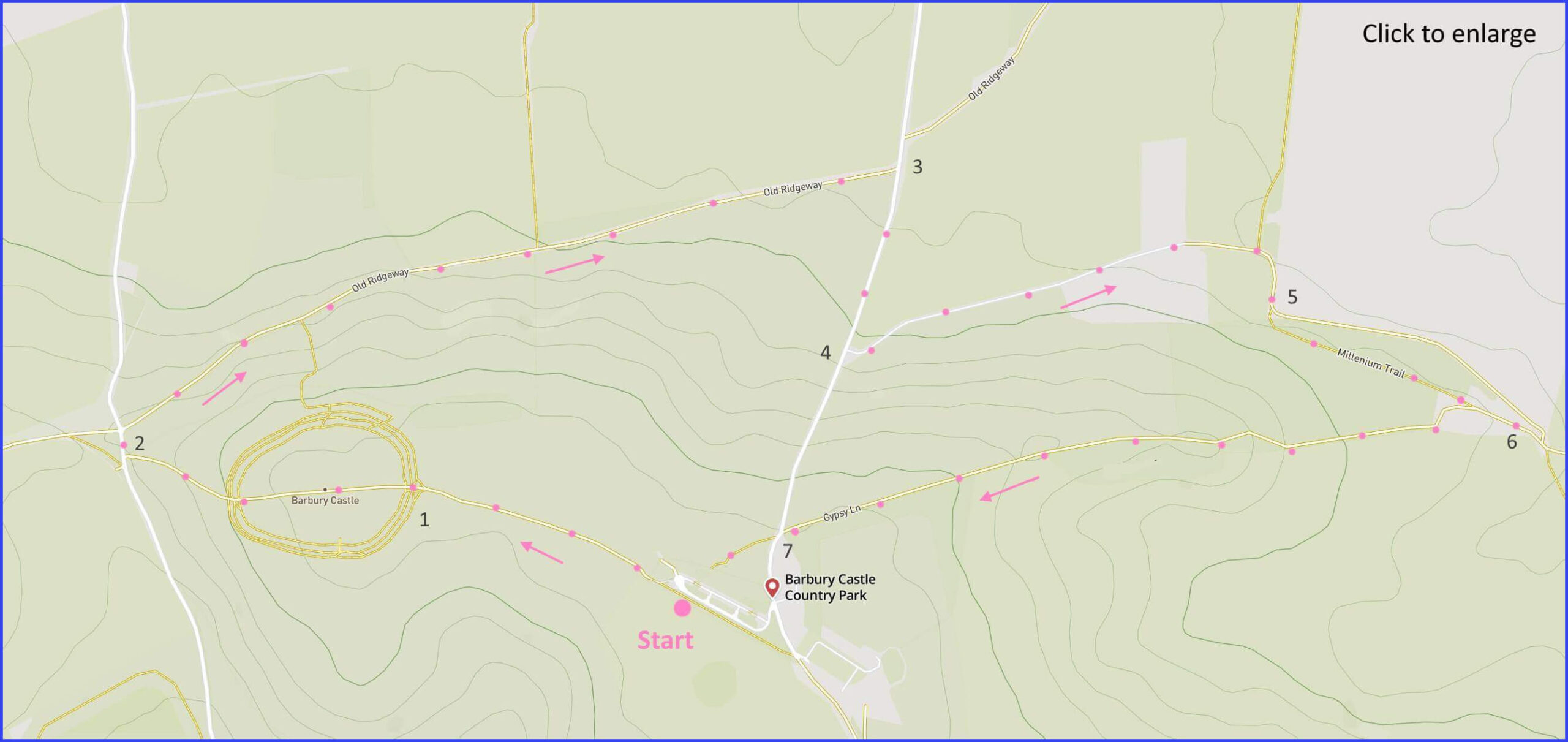
(Routes suggested from each map point + metres to next point)
Start: From the car park follow signs to ‘Barbury Castle’. 570m
1 Mount ‘castle’ on slight elevation and walk across to other side. Drop down slope, pass a notice on your left and join lane. 520m
2 Right here and briefly join Old Ridgeway rough path to the right. 1.5km
3 Join entry road to the Park. Turn right up hill. 340m
4 Take left road towards shooting centre. 860m
5 After veering right away from the centre, take a level path that runs alongside the bottom edge of field. 530m
6 Enter overgrown area at end of field/fence. Continue forward. Cross stile on barbed wire fence to your right. Continue veering rightwards until another fence and stile with open hillside beyond. Ascend towards summit. 1.4km
7 Cross road and join field path opposite leading to your starting point. 240m
The pictures below are in the order things were seen on this walk. Clicking on any one will enlarge it (and the slideshow)
![[A]](https://wiltshirewalks.com/wp-content/uploads/2022/10/barbury_01.jpeg)
![[B]](https://wiltshirewalks.com/wp-content/uploads/2022/10/barbury_02.jpeg)
![[C]](https://wiltshirewalks.com/wp-content/uploads/2022/10/barbury_03.jpeg)
![[D]](https://wiltshirewalks.com/wp-content/uploads/2022/10/barbury_04.jpeg)
![[E]](https://wiltshirewalks.com/wp-content/uploads/2022/10/barbury_05.jpeg)
![[F]](https://wiltshirewalks.com/wp-content/uploads/2022/10/barbury_06.jpeg)
![[G]](https://wiltshirewalks.com/wp-content/uploads/2022/10/barbury_07.jpeg)
![[H]](https://wiltshirewalks.com/wp-content/uploads/2022/10/barbury_08.jpeg)
![[I]](https://wiltshirewalks.com/wp-content/uploads/2022/10/barbury_09.jpeg)
The walk
A long single track road directs you to the parking area. You will find the start of the route mapped above is well signposted. First you walk to the level top of Barbury Castle – it does not feel like a raised mound when you are close up or upon it. It may help orientation to look at this aerial video. However, walk across the top and descend to the other side where there is a signpost describing the whole area [C]. Drop down to the lane and follow the path to the right so that the hill fort remains on your right. Now you are on the ancient Ridgeway for a short distance (until meeting the road) There are fine Wiltshire views to your left. Something in the distance that might look like a lake is actually a large solar farm.
The path becomes pleasantly wooded [E] before reaching the road you probably drove up to arrive here. Right then first left. This takes you towards a shooting practice ground. Sadly the presence of this facility is likely to mean the sound of a rifle crack intermittently – say about every 30 seconds on average, audible at all distances. This rather spoils the walk. But persevere. The only challenge might be getting from point 5 to 6 on the route map. It’s relatively easy walking but path directions are not as clear as they might be. On passing away from the shooters you walk up a slight slope, turn left half way and follow the field edge to a wooded area which you enter and bear rightwards. Once through to the open area slope you are ready to climb back to the castle/fort
Barbury castle
This hill fortification was probably constructed around 700BC and may have been in use well into the era of Roman occupation. Evidently a fort is about defence and defence is, in part, about making threats visible. Therefore visiting this site suggests there will be good views over the local area. And that is certainly the case. Barbury castle is one of a group of similar settlements that run along the Wiltshire Ridgeway. Perhaps it is among the most impressive, as it is set upon the highest point of the immediate area.
The castle forms a double rampart which until this day has retained its steep protective shape. During the Second World War its prominent location led to military use. One consequence of this has been a certain amount of damage. For instance, the original entrances had to be widened to allow army vehicles to get access. On the other hand, the digging and disruption of this period also uncovered some important archeological remains, including a variety of tools and weapons from a later period of the first Millennium B.C. If you wish to sample a Wiltshire hill fort – this one is strongly recommended.