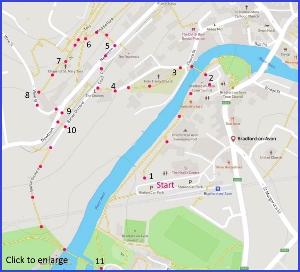
BA15 1LF A (in total) 5.5 mile walk around Bradford on Avon in two parts. For both the Station (zone B) is recommended for parking. The walks fit together fine but can be separated. Click here for arial view. Click here to download/print PDF. (There is a GPX route option here for phone/tablet download. But only follow this link after watching this GPX help video). Friendly warning: all files relating to walks are published here on good faith but on the understanding that users must be responsible for their own safety and wellbeing.
Instructions below show routes from each map point + metres to next point
2 Circle left to find river and cross it towardds church. 80m
3 Perhaps visit Saxon Church and Parish church. But otherwise walk through parish church yard to exit on road and walk upwards to start of footpath. 130m
4 Other end of churchyard and up sloped path to left. Turn right on reaching Coach Road. Briefly up to junction with Newtown. Cross. 85m
6 Drop down a few yards and take pathway on right up to ‘Tory’. Head left along a row of houses to street and reach chapel. 60m
9 Find downwards path almost opposite Wine street junction. Take path on left down to join Barton Orchard road. 50m
10 Follow Barton Orchard path until reaching river and cross and either do walk #2 or return to car park
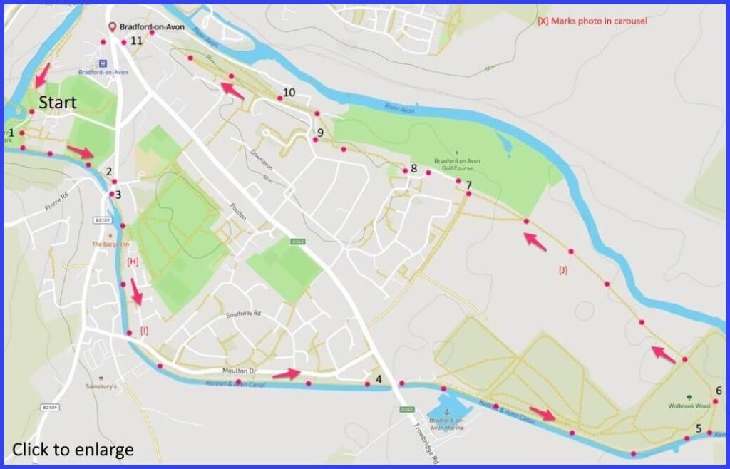
Part 2 – Canal and River walk
The part 1 walk (above) ends (point 11) just atove point 1 on this map. If only doing Part 2 then take footpath out of Zone B car park and head towards canal and Tithe Barn (point 1). (There is a GPX route option here for phone/tablet download. But only follow this link after watching this GPX help video). Friendly warning: all files relating to walks are published here on good faith but on the understanding that users must be responsible for their own safety and wellbeing.
Instructions below show routes from each map point + metres to next point
1 At this point theTithe Barn may be visited. If so, once completed exit back onto path and original point 1. Walk up path/stops to the canaside towpath. Turn left and follow path towards the main road. 350m
2 Main road. Turn right and walk a few yards to cross at bridge and rejoin the towpath. 75m
3 Then walk the towpath going under one bridge and continuing walking under Trowbridge Road bridgetowards road bridge. 1.2km
4 Continue on towpath until gate on left. 1km
5 Drop down beside wood and head left. 90m
6 At marker post walk through wood and then across 3 vfields until passing between houses. 1km
7 Be careful to take the cul de sac exit path on right and path flanked by houses and line of trees (Mythern Mdw). 180m
8 Follow path that is on boundary of golf course. 200m
9 Drop down path and turn left to Y-split in path. 250m
10 Either fork will work but take left, returm to main road and signs to station park. 500m
The pictures below are in the order things were seen on this walk. Clicking on any one will enlarge it (and the slideshow)
The walks
Bradford’s identity is defined by the mediaeval wool trade. And the names of the powerful families that shaped it: Druce, Hobhouse, Horton, Lucas, Methuen, Thresher, Tugwell, Shrapnell (wool and guns that one). First, it was ‘white broadcloth’ (1300 – c.1650), then a contraction towards the dyeing of superior Spanish wool (thanks to Methuen importing Dutch craftsman). Water was the key. The Avon powered the mills but also shipped the goods to Bristol. Two routes are suggested here – although the resilient walker could do them in succession. The first meanders through the old part of the town on its hillside (so paved but some inclines). The second takes a canal towpath and then back to town through field paths. Parking is suggested at the railway station car park.
Two churches
A monastery here was granted to Shaftesbury Abbey in pre-Norman times. Supposedly to ensure the safety of Shaftesbury’s nuns from marauding Danes. However, around 1015 Canute still slipped up the River Frome and invaded. Nevertheless, the first sighting on this walk is a remnant of this period. Bradford’s Saxon Church [A] is one of the best-preserved in the country. For centuries it lay unnoticed, performing other roles, until a Canon Jones discovered it in 1856. One doesn’t see many 1000-year old intact buildings – so take a look.
That church may have fallen from view with the building of a parish church next door (Norman, although much modified). Church detective Canon Jones was the rector. Characteristically, the great wool families are celebrated inside: Thresher (north chancel window), Hortons (east chapel and brasses), Methuen (monument), Tugwells (all over one chancel wall).
‘Newtown’
Holy Trinity churchyard forms the start of an upwards walk towards the roads Newtown, Middle Rank and Tory (“hill”). 39 Newton used to be the White Lion pub. Just visible is a sign advertising home brewed ales. In the mid seventeenth century there were around 13 alehouses in the town and many of them had their own brewery. The eighteenth-century houses on Newtown convey a sense of grand mansions rendered small. While the Middle Rank houses are more modest and were probably occupied by wool finishing craftsmen (windows too small for weavers).
The walk along Tory offers a fine view of the town [C]. At its end is the Chapel of St Mary – largely rebuilt but once a stopping point for pilgrims (perhaps to Glastonbury). Underneath St Marys there was once a quarry, at least until the end of the 19th century. It probably provided stone for many local buildings. At the bottom of Wine Street and built against the quarry face are the buildings of the Wilkins brewery (evident, but now converted). Early Wiltshire historian John Aubrey commented that this south facing area would make perfect vineyards. “Wine Street” may be a clue of at least a good intention if not some experiment.
Tithes
‘Part 2’ of the walk starts by crossing the railway [E] and then the Avon. The river crossing is a 14th century packhorse bridge. In the mediaeval period it would have been used to reach the great barn where tithes would be due to the Abbess of Shaftesbury for funding the church. The quantities of grain tithe carried here would have been large enough to suggest avoiding the town bridge – with its associated toll. The Barn (c 1332) at Barton Farm is extraordinary – being of cathedral dimensions [G] with a striking roof (supporting 100 tons of stone tiles) and with large openings for those grain-bearing carts to enter and exit.
Canal
The walk is flat and easy – although refreshment can be considered at the Canal Tavern before starting. The towpath restarts across the road.The right hand bank from this point to the road bridge that crosses the towpath [i] is the site of the former Canal Quarry. This was an area of great scientific significance because the ‘Bradford Clay’ found here (during digging for the canal) turned out to be a site of an important fossil find. These fossils have now scattered to museums across the world. There are two wartime pillboxes to be spotted. One just beyond the packhorse bridge and a second close to the road bridge you walk under. They are both Type 24 as seen on this map of the ‘GHQ Stop Line Green’ set up to anticipate a German land invasion.
Industrial yet pretty
Bradford was one of the most successful of Wiltshire wool towns. Yet industrial prosperity is not usually associated with the kind of prettiness apparent in the town today. While this may be unexpected, it can be explained. The explanation would be in terms of how events positioned Bradford after the slump in the wool trade. At first, the town adapted well in the 17th century by starting early with the new coloured cloths. Indeed, the London merchants were sufficiently alarmed at competition for their exporting that they started agitating the Bradford traders with aggressive quality checks (one inspector, Anthony Withers, was thrown in the Avon by an angry crowd of workers). But this was not enough to ensure town prosperity.
The decline in the wider wool trade was coupled with the industrialisation of what was traditionally a more domestic-based craft. There were luddite-style riots resisting this but, inevitably, unemployment poverty increased. Bradford could still have flourished by embracing these new ways. But its mills had previously thrived on water power and were slow to modernise by adopting the new steam-based alternatives. Finally, the town was not well placed to attract alternative industries. Consequently to its prettiness, there was no legacy of 19th century slum housing that might have accompanied such expansion.
On the other hand, large buildings from the milling tradition do remain visible. In many cases these have been creatively re-purposed. Although they did help Bradford successfully attract one particular 19th century industry – namely, rubber. Stephen Moulton recognised the available factory space and workers familiar with the discipline of factory life. His rubber business engineered buffers, springs and hosing for the 19th century railway companies. Moulton’s grandson carried the business into the 1950s with the first small-wheeled bicycle (no, it didn’t fold)


![[A]](https://wiltshirewalks.com/wp-content/uploads/2022/01/IMG_1526-150x150.jpg)
![[B]](https://wiltshirewalks.com/wp-content/uploads/2022/01/IMG_1537-150x150.jpg)
![[C]](https://wiltshirewalks.com/wp-content/uploads/2022/01/IMG_1541-150x150.jpg)
![[D]](https://wiltshirewalks.com/wp-content/uploads/2022/01/IMG_1548-150x150.jpg)
![[E]](https://wiltshirewalks.com/wp-content/uploads/2022/01/IMG_1550-150x150.jpg)
![[F]](https://wiltshirewalks.com/wp-content/uploads/2022/01/IMG_1555-150x150.jpg)
![[G]](https://wiltshirewalks.com/wp-content/uploads/2022/01/IMG_1557-150x150.jpg)
![[H]](https://wiltshirewalks.com/wp-content/uploads/2022/01/IMG_1562-150x150.jpg)
![[I]](https://wiltshirewalks.com/wp-content/uploads/2022/01/IMG_1564-150x150.jpg)
![[J]](https://wiltshirewalks.com/wp-content/uploads/2022/01/IMG_1571-150x150.jpg)