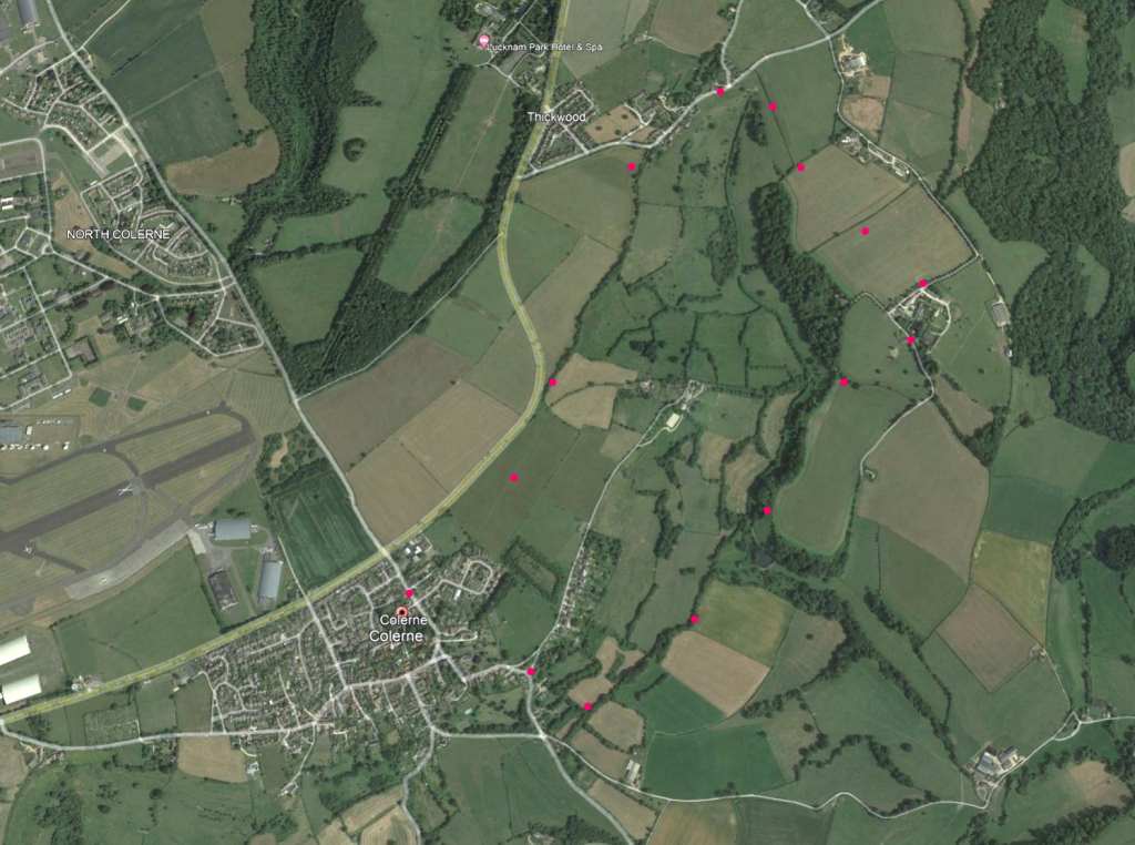
SN14 8DP. Walk around Colerne. The map (click to enlarge) shows a no-traffic 4.5 mile walk with some slopes and sometimes a little muddy Click map to enlarge. Water is blue, wooded green, contour lines show slopes. Click here for an aerial view. Click here to download/print PDF. (There is a GPX route option here for phone/tablet download. But only follow this link after watching this GPX help video). Friendly warning: all files relating to walks are published here on good faith but on the understanding that users must be responsible for their own safety and wellbeing.
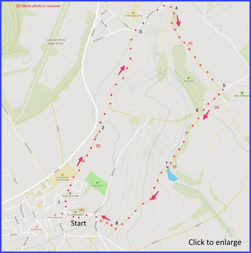
(Routes from map points + metres to next point)
Start See village church (picture A). Exiting, turn right away from market cross and join Quarry Lane. Enter footpath just be public toilets on right. 100m
1 Pass village hall and nursery; follow straight route to edge of primary school grounds, take path to far left corner of field. 500m
2 Here there is a junction. Don’t take gate on right, take path ahead, down a slope onto tree-canopied broad walk (B) – pass possible short cut (C) – until junction with Thikwood Lane. 500m
3 Head rightwards, passing telephone library, follow lane until a junction at which open a right-facing gate and drop down 20 yards. Don’t go through the gate on your right. But follow the path to its immediate left signed EURIDGE (warning Brexiteers), not dropping down but bearing up field to left [close view here]. 380m
4. Walk across three fields (E) to lane entrance by farm buildings. 500m
5 Briefly join the lane for 20m before picking up downhill signed footpath through centre of field (G) [close view here]. 160m
6 A junction in hedgerow where a broader track (I) should be taken down leftwards through wooded area towards small body of water. 680m (comment advice :At point 6 as you go left there is a no entry sign for walkers, I followed the way marked sign however that is not correct. I walked back along the stream to the crossing point. Ignore that no entry sign! At point 8 as you walk the path back to the village you come to a stile with a T-Junction of paths, turn left then walk back across the meadow to the village)
7 Cross the stream here (J) and follow the path to a junction with a path to the right. 675m
8 Take this (short cut) path that returns you to village. 400m
The pictures below are in the order things were seen on this walk. Clicking on any one will enlarge it (and the slideshow)
![[A]](https://wiltshirewalks.com/wp-content/uploads/2021/10/01colern.jpg)
![[B]](https://wiltshirewalks.com/wp-content/uploads/2021/10/02colern.jpg)
![[C]](https://wiltshirewalks.com/wp-content/uploads/2021/10/03colern.jpg)
![[D]](https://wiltshirewalks.com/wp-content/uploads/2021/10/04colern.jpg)
![[E]](https://wiltshirewalks.com/wp-content/uploads/2021/10/05colern.jpg)
![[F]](https://wiltshirewalks.com/wp-content/uploads/2021/10/06colern.jpg)
![[G]](https://wiltshirewalks.com/wp-content/uploads/2021/10/07colern.jpg)
![[H]](https://wiltshirewalks.com/wp-content/uploads/2021/10/08colern.jpg)
![[I]](https://wiltshirewalks.com/wp-content/uploads/2021/10/09colern.jpg)
![[J]](https://wiltshirewalks.com/wp-content/uploads/2021/10/10colern.jpg)
The walk
This village is pretty much at the junction of Gloucestershire, Somerset and Wiltshire. As such it qualifies for a ‘Three Shires Stone’ marker (its close by but not on this walk).
The first part of the walk is wide, often tree-covered, and affording good views to the right (but some traffic noise to the left). The turning point is at Thickwood – a cluster of pleasant houses and a red phonebox library. It’s a kind of ‘Upper Colerne’ although perhaps older, with evidence of Roman settlement – but then it is very close to the Fosse Way.
The middle third (don’t head downwards at map point 4) crosses a couple of fields (some footpath marker posts help orientation) to converge on the 19th century Euridge Manor, which Pevsner notes has been transformed into “an Italo-Elizabethan hillside fantasy”. The last part – a track leading back to the village – can get muddy and is a bit more tiring in slope terms. Yet the village will be welcoming with its apparently permanent state of peace.
The village
This ‘village on a hill’ does deserve a stroll around before starting the walk proper. Pevsner says that approaching from the South you could be in Tuscany. Well.. perhaps. Its well-defended location attracted an Iron Age settlement and, later, the Romans built a villa nearby. While, later still, Saxons occupied the area. From 1387 until 1877 the Manor was owned by New College, Oxford. To whom Henry VI granted a Friday market and fair. But links to the wool trade from the Middle Ages are evidently long past.
Colerne would have prospered well enough, at least until the nineteenth century. It was a base for stone quarrying, sheep farming, and cloth-making. It was a temporary settling place for labour involved on the building of nearby Box railway tunnel. Today it has all the “Ps” that Country Life magazine assert are needed for successful village life: that is, pub (2), post office, primary school, place-for-worship and public transport.
The community would have been relatively isolated – at least until just before the Second World War when its association with “the camp” was sealed. That is to say, the formerly RAF Colerne, important as the prime fighter station in the later stages of the war. Subsequently it closed and now it is a site for military satellite systems processing data from battlefield drones.
In more peaceful terms, the village offers some pleasing old houses set higgledy piggledy around the High Street. Much of the older housing you will see is late 18th century – reflecting significant rebuilding following a fire in the town. Note Dauhenys (opposite the Fox and Hounds), a late medieval ‘Long House‘ (once serving to keep people and animals in the same dwelling) – a structure apparently rare in Wiltshire. For refreshment, there are two pubs (the Six Bells is arguably the better), one general stores, and the post office.
The church of St John the Baptist is 13th century ‘much modified’, and more substantial than most in scale. Note the fine tower (1450) and, inside, the interesting positioning of the organ pipes. Also the tomb of Richard Walmesley (19th century cricketer and lawyer) with its lifelike marble effigy of the man – perhaps wisely prepared for the next world in his nightshirt and holding a bible. Walmesley is also honoured (for “benevolent acts”) within a small green enclosure in the market place. Although he lived a mile or so away in Lucknam Park (now a boutique hotel).
The village can feel rather eerily deserted. Almost as if Steed and Mrs Peel might drive through in a little soft top number and start investigating that suspicious “village hall” for its part in some eccentric plot. The corner shop was friendly but an attempt to buy mushrooms was met with “sorry, they just fly off the shelves first thing in the morning”. As they do.
Lovely walk in Spring Sunshine, just a couple of direction observations: At point 6 as you go left there is a no entry sign for walkers, I followed the way marked sign however that is not correct. I walked back along the stream to the crossing point. Ignore that no entry sign! At point 8 as you walk the path back to the village you come to a stile with a T-Junction of paths, turn left then walk back across the meadow to the village
Ah – thanks for this. I will try and modify the map. Inevitably these direction can be unstable but glad you still enjoyed