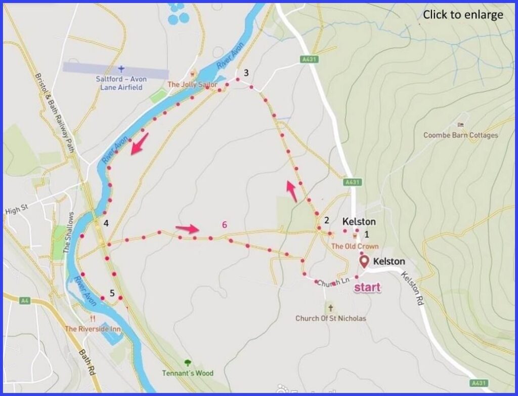
(Routes from map points + metres to next point)
Start: If parking in Church lane, walk up to main road and walk left towards pub. 220m
1 Locate left turning lane just beyond the pub and before an old red phone box. Proceed towards Soft Cheese farm. 275m
2 Bear right to walk past the Cheese farm signposted to Kelston Mills (don’t be tempted to veer right and be confident about the farm surroundings – but cross a gate into a field (and then another) always walking diagonally to join a lane. Head towards river. 750m
3 Lane veers to the left and allows you to pass a set of 3-storey houses (pic D). This is Kelston Mills. Turn right after these and use the footpath that runs close to the bank of the river (pic F). 1km
4 Walk under hi-grafitti railway bridge and onwards tracking river towards a lock. 650m
5 Take left turn (pic G) inviting a fenced walk up to the disused railway line. Walk left on this route until a path drops down about 300 yards further on. Take the field path. 875m
6 Take a right branch on a 3-way path junction. Crossing fields [H] towards farm, cat hospital [I] and your starting point. Chance to visit church. 575m
The pictures below are in the order things were seen on this walk. Clicking on any one will enlarge it (and the slideshow)
The walk
Parking is possible on Church Lane. It is a settlement of two parts: first, on the unmarked road leading to the church, there is a group of elegant nineteenth century houses (including a ‘cat hotel’ – pic I). While the second part of the village comprises a scattering of dwellings lining the busy A431. The walk is a mixture of field paths and a path that runs alongside the River Avon – where is much wildlife (including humans) activity to observe. The half way point brings you onto an old railway that is part of the National Cycle Network.
Toilet history
Accounts of this area tend to be dominated by the colourful figure of Sir John Harrington. This Tudor poet (poor) and courtier (disgraced) was godson to Queen Elizabeth I but he got himself banished to Kelston for various misbehaviours. Here Harrington built a house adjacent to the church, within which he designed and installed the first ever flushing lavatory (he called it ‘Ajax’). This device was not widely copied at the time but did impress the queen – who apparently ordered one – and in that way his reputation was to some degree recovered. And the village acquired historical ownership of a distinctive cultural invention.
Later, King James I honoured Harrington with the entirety of Kelston Manor and the right of appointing rectors to the local church living. Harrington’s Kelston House no longer exists, but later, in 1760, John Wood the Younger was commissioned to match it with a large mansion on land where Harrington had built his summerhouse. This new Kelston Manor included grounds designed by Capability Brown. Over a long period the Manor somewhat deteriorated under various owners. However, in 2021 approval was given for it to become a 30-bedroom hotel.
Traditional businesses
The walk releases you from Kelston’s A431 with its staring point at Kelston Forge – which is still functioning through the local blacksmith (see examples of their work here). Shortly, there appears another significant business of Kelston – the farm buildings of the Bath soft cheese company. Walk through their site, admiring their organic practices – perhaps even considering a (rather early) break at their stylish café.
The Mills
From walking across a couple of fields you approach the Avon but, first, the village of Kelston Mills. The ‘mills’ of Kelston served the brass rolling works that dominated this area from the early C18. What is more evident now is the small marina. But two dilapidated furnace chimneys and the outer walls of the old mills are still visible – having ceased operating around 1840. And the three-story cottages passed on the walk were formerly the dwellings of mill workers. Some of them may have been Dutch, as a local industrialist (Abraham Darby) had travelled to The Netherlands to learn the relevant techniques for making brass pots – and tempted some workers over. Some Dutch surnames apparently survive in the village.
The most effective means of rolling brass depends on the material being softened by heat (‘annealing’). This site at Kelston was very suitable for such work because of the access to both local coal but also the Avon water. Brass goods made here were often sent to West Africa from Bristol where they were bartered for slaves (who were taken to the West Indes to produce sugar that was sent back to Bristol – a tragic loop).
The old rails
The walk along the Avon goes under (and then up to) the Bristol and Bath Railway Path. This is a 15-mile part of the National Cycle Network (Cycle Route 4). It opened in 1984 and was the first part of what then grew into the NCN. The path took over what was formerly the route of the Midland Railway Mangotsfield and Bath branch line (Beeching Axed in the 1960s). Close to this bridge and on the other side of the river was Kelston Station (1869) – although it was closer to Saltford than Kelston and was actually known as “Kelston (for Saltford)”, even though Saltford had its own (GWR) station. Basically it wasn’t much use – although did serve to take some punters over the hill to the Landsdowne races. Kelston station closed in 1948. The line itself remained open for passengers until 1966 and for goods to Bath until 1971. Beware of fast moving lycra-clad cyclists but, otherwise, it provides a peaceful and canopied start for taking the paths back to Kelston proper.
Here the church is worth a visit. Some C13 features (slit windows) although Pevsner notes the “ruthless restoration” of 1859. Finally, there are good refreshments opportunities at the Old Crown pub.


![[A]](https://wiltshirewalks.com/wp-content/uploads/2021/10/01kelst-150x150.jpg)
![[B]](https://wiltshirewalks.com/wp-content/uploads/2021/10/02kelst-150x150.jpg)
![[C]](https://wiltshirewalks.com/wp-content/uploads/2021/10/03kelst-150x150.jpg)
![[D]](https://wiltshirewalks.com/wp-content/uploads/2021/10/04kelst-150x150.jpg)
![[E]](https://wiltshirewalks.com/wp-content/uploads/2021/10/05kelst-150x150.jpg)
![[F]](https://wiltshirewalks.com/wp-content/uploads/2021/10/06kelst-150x150.jpg)
![[G]](https://wiltshirewalks.com/wp-content/uploads/2021/10/07kelst-150x150.jpg)
![[H]](https://wiltshirewalks.com/wp-content/uploads/2021/10/08kelst-150x150.jpg)
![[I]](https://wiltshirewalks.com/wp-content/uploads/2021/10/09kelst-150x150.jpg)
![[J]](https://wiltshirewalks.com/wp-content/uploads/2021/10/10kelst-150x150.jpg)
Section alongside river practically impassable after Jan/Feb rain. Had to retrace our steps and climb Kelston Round Hill instead!
Sorry to hear that!