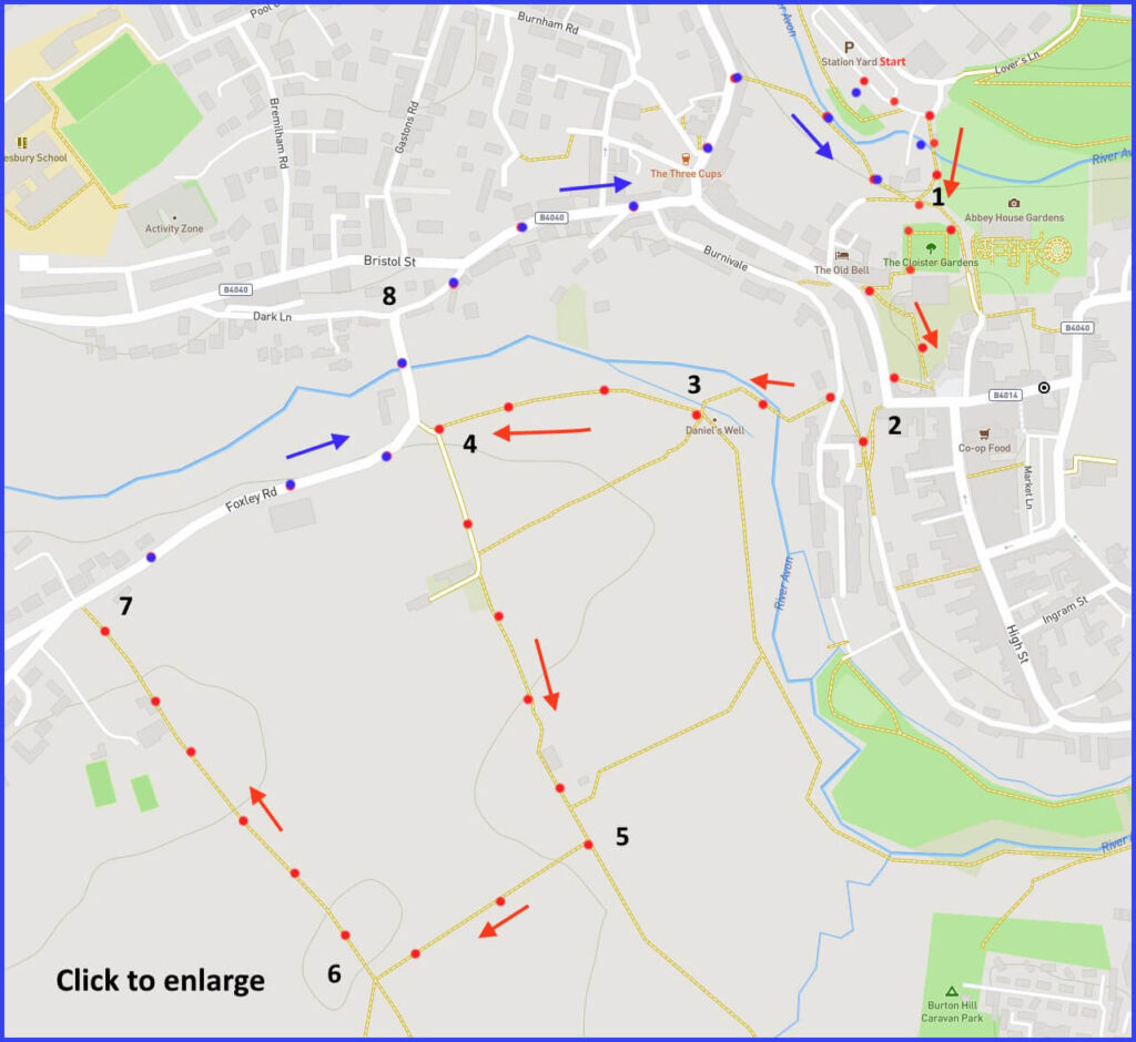
SN16 9JT A short walk around Malmesbury (3 miles) combining exploring an historic small town with easy rambles across adjacent fields. Click map to enlarge. Click here for an aerial view. Click here to download/print PDF. (There is a GPX route option here for phone/tablet download. But only follow this link after watching this GPX help video). Friendly warning: all files relating to walks are published here on good faith but on the understanding that users must be responsible for their own safety and wellbeing.
(Routes from map points + metres to next point). Return third of walk marked blue to distinguish from start third.
Start: From car park: Walk uphill heading towards the (signed but prominent) abbey complex. 220m
1 (Tricky in words – so see closeup map here.) Walk along the top path of the square Cloisters Garden towards the west front of the Abbey. Follow that path down through a grassy grave space, turning sharp right shortly before it meets the main road and market cross. Follow the path so that y0u can enter the road at a point further up from a 90 degree bend. Turn left (on this Gloucester Streeet), walking down towards that 90 degree bend. 210m
2 Join ‘Kings Wall’ heading downwards through a stepped old street [B]. Take an abrupt about turn at a V-junction (now going up Kings Wall). This leads to a junction with a road (Burnaivale). Immediately cross road to find a footpath going down to river crossing [C]. 125m
3 At Daniel’s Well [E] (a small pool of water) walk away from the ‘well’ towards an intersection of paths, following the right heading one (parallel to river) to a path intersection just before Foley Road bend [closeup here]. 200m
4 Take a sharp left and follow track at clump of trees and stone wall. Forward towards farm buildings and a second field. Then onward, walking along the edge of a further field. 380m
5 Before turning right here, be sure to then walk on the nearside of the hedge-lined field, now walking at right angles to your previous route – taking you to a stile/gate. 225m
6 Turn right onto thin wooded path [I] taking you to a road junction. 320m
7: Take this Foxley Road veering right, back into town and return to car park
The pictures below are in the order things were seen on this walk. Clicking on any one will enlarge it (and the slideshow)
The walk
Parking recommended in a long term car park that is very central to the town. The present route offers twin pleasures: a small but historically important town coupled with a peaceful countryside walk. Unusually, that countryside butts directly onto the historic centre, such that a walker moves from bustle to tranquillity barely noticing the transition. Following the lanes of the town down to the river is a little tricky and you may end up improvising. The river leads to pleasant field paths and a level lane back into town.
Early history
This hilltop town is encased by converging branches of the River Avon. Being so well-defended made it a focal point for significant historical conflicts, but also a secure seat of learning centred on its Abbey. Moreover, the river setting contributed to its wealth as a wool town in the period after the monasteries were dissolved by Henry VIII. Sadly, where water and hilltop features once contributed to its military and weaving importance, these very same features excluded it from the emerging transport systems of canal and railway. It became a quiet market town serving Cotswold visitors.
There is evidence of an iron age fort in this area and Roman coins have been found at Malmesbury. However, first and foremost, this is a Saxon town. A Celtic Christian mission was created here (640) by Maldulf. Shortly after, Aldhelm (639-709) established Roman Christianity and a Benedictine order. Malmesbury was one of a network of fortified towns created by King Alfred on the boundary of Mercia and Wessex – to offer retreat from invading Vikings (and other marauding hoards). Alfred’s successor, Athelstan, the highly effective first king of all England, had a special respect for this town and is buried in the Abbey (AD 940).
Mediaeval history
In the Norman period, the largest holder of Wiltshire land would be the King (about one fifth) but then it would be the four ecclesiastics – one of which was Malmesbury (along with Salisbury, Glastonbury, and Winchester). In this early medieval period William of Malmesbury (1095-1143), who was then the Abbey librarian, became the most important English historian after Bede.
Later, during the Reformation, the (dissolved) Abbey was purchased by a clothier (proto-capitalist, William Stumpe) who set up many looms for weavers in its factory-scale space. The congregation of domestic or craft-based production skills in a shard space (say, a ‘factory’) was to become a key feature of political, economic and cultural change. Thus Malmesbury and Stumpe might be considered industrial ‘pioneers’. Certainly these developments made cloth manufacturing very important to this town and its standing. (Although Stumpe’s property acquisition had a community dimension, for he also granted to the town the nave of the Abbey as a local church.) Up until the mid-C18. Malmesbury was strategically important during the Civil War although it changed hands a number of times. The West end of the Abbey has many bullet holes – suggesting a final place for prisoners of war.
Malmsbury now
In recent times Dyson has been the main employer. Unfortunately its fervent Brexiteer boss recently moved his headquarters to Singapore during the “we got it done” aftershock. In that year Dyson’s profits had topped £1 billion – a 28% year-on-year rise. While this was therefore clearly a loss to the town, the Dyson company does at least maintain a brain hub of engineers and AI people – for whom the Cotswolds ambience is probably a good recruiter.
Time taken wandering the town would be rewarded. Particularly around Oxford Street and High Street. Near the Abbey, The Old Bell claims to be the oldest hotel in England. Recently its future started to look precarious. However, it is now owned by Whim Hospitality based in Dripping Springs, Texas. Hopefully their hospitality adopted in Malmesbury will include directing guests to the nearby market cross (1500) – said by Pevsner to be “one of the finest in England”. The Abbey itself should also appeal to visitors; hopefully they will notice the Wiltshire Blind Houses that are neatly integrated with the Abbey entrance arch (these ‘houses’ were windowless prisons for petty offenders). Less well known about Malmesbury Abbey is its reputation as the site of the first documented attempt at human flight. In the year 1010 monk Elmer jumped from its tower wearing homemade wings. He broke both legs. But thereafter lived a long and scholarly life.
Afterthought
Having walked down a few winding streets [B], the countryside bursts in at the point of a depression called Daniels Well [E]. This name refers to a former bishop, Daniel of Winchester, who was educated at the Abbey and, after losing his sight, lived there until his death (in 745). Apparently he would daily submerge himself in this water to quell fiery passions. Try it if you need to. The walk then sends you across a number of farmed fields and back into the town.


![[A]](https://wiltshirewalks.com/wp-content/uploads/2021/11/01malms-150x150.jpg)
![[B]](https://wiltshirewalks.com/wp-content/uploads/2021/11/02malms-150x150.jpg)
![[C]](https://wiltshirewalks.com/wp-content/uploads/2021/11/03malms-150x150.jpg)
![[D]](https://wiltshirewalks.com/wp-content/uploads/2021/11/04malms-150x150.jpg)
![[E]](https://wiltshirewalks.com/wp-content/uploads/2021/11/05malms-150x150.jpg)
![[F]](https://wiltshirewalks.com/wp-content/uploads/2021/11/06malms-150x150.jpg)
![[G]](https://wiltshirewalks.com/wp-content/uploads/2021/11/07malms-150x150.jpg)
![[H]](https://wiltshirewalks.com/wp-content/uploads/2021/11/08malms-150x150.jpg)
![[I]](https://wiltshirewalks.com/wp-content/uploads/2021/11/09malms-150x150.jpg)
![[J]](https://wiltshirewalks.com/wp-content/uploads/2021/11/10malms-150x150.jpg)