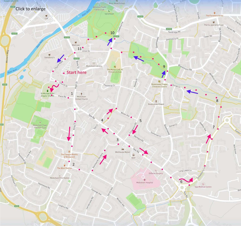
(Routes suggested from each map point + metres to next point)
Start: Exit car park, turn right on Church Street. Left at war memorial towards church. Follow church north side towards Place Road. Walk to High Street: 420m
1: Head right towards market square, entering King Street. Walk to junction with Waverly Gardens on left path: 460m
2: Walk towards a left turn into Kenilworth Gardens, veering right at end and entering Spa Road: 480m
3: Turn left. Just over hump in road find Harde Walk path a right turn on other side of road: 160m
4: Take path to right turn at end onto Milton Avenue: 290m
5: Right turn onto Coronation Road to complete a square back to Spa Road. Turn left and follow to roundabout: 660m
6: Take left exit onto Strawberry Lane and walk to a signed footpath on left side: 430m
7: Follow path [D] to sign for Primrose Nature Area just before bridge over stream [E]: 170m
8: Walk left to follow path alongside stream: 400m
9: Cross Queensway and continue, now above the stream until road that joins Lowbourne. Cross. Right towards Park entrance: 430m
10: Walk to path junction, following left route downwards to cross stream: 200m
11: Join Union Street at Baptist chapel and Zebra cross to walk upwards on Bank Street shortly taking right turn into Church Walk. At which end, turn right and find starting point: 400m
The pictures below are in the order things were seen on this walk. Clicking on any one will enlarge it (and the slideshow)
About Melksham
Although Melksham is about the same size as its market town neighbours (Chippenham, Trowbridge, Devizes, Westbury, Bradford etc.), it is not as visually rewarding as some of those. Neither does it seem as prosperous, even though it must be one of the most industrialised towns in Wiltshire – after Swindon. And it has a long history as such: agriculture for sure, but also clothing in the 16th century (white undyed broadcloth), mats, rope and twine (C.W. Maggs and Co.) and more recently rubber (“home of Avon Tyres”) and engineering (Spencers)
But there is at least one thing that makes the town rather distinguished: it gave its name to a prehistoric crocodile species. Ieldraan melkshamensis was accidentally discovered here and was then named ‘Melksham Monster’. The beast was a 10 ft predator active in Melksham’s Jurassic period.
Ancient history of a more human kind has been revealed in recent archaeological finds dating settlements here back to the early Roman period.
Town centre
Coming out of the car park that is suggested here as starting point (you will need coins), you might notice an 18th century stone Round House across the road. Melksham having once been a wool town, round houses were used for drying. This example is a rare survivor. Although finding a sustained use for it seems to have been a struggle – variously it has been an armoury, feed store, tourist centre and museum. If it’s open (currently its a small charity), take a look inside.
Walking along Church Street towards the 1919 war memorial (the old vicarage is behind it), you catch a pleasing mix of old cottages [A] and Georgian houses (north side near church path). Entering St Michaels churchyard, is an old Yew tree [B] precariously propped above the tombs. The present church dates back to the 12th century, although it has undergone much renewal at various times since. Happily , when I visited it was not only open – there were two chaps inside agreeably anxious to talk about church and town.
Then through the churchyard to Place Road. This is where Melksham’s 16th century manor house once stood, facing the market place,, its gardens extending back to the church. After a succession of owners the Manor was purchased by Melksham businessmen. They demolished it and auctioned the land for small plots. Apparently many were taken up by dissenters, even though they were unhappy about Place Road offering through passage to the church. Opposite the other end of Place Road and on the High Street is the Kings Arms (1800): once an important coaching Inn on the London to Bath road and still something of a social hub for the town. Walking to the right leads to the old market place – overseen by the 1847 Melksham Town Hall.
King Street
This is one of the seven original approaches to the town. It may not seem to have much charm – but there is some if you work at it. So there are at least six listed buildings between No. 2 and 16 at the start of the street. One was a Friends Meeting House from 1698 (Quakerism was quite active in the town). While further along the street (numbers 47-57, over on the left side) is an attractive line of (colourful) houses – also listed.
It is hard to believe from the landscape here today that the Berks and Wilts canal once ran through this area – linked to the Kennet and Avon at Semmington. (What a difference the presence of that canal would make today!) The route it once took can be seen on this map. The canal ran beneath the current housing of Kennilworth Gardens and towards “Wharf Court”, taking a name that identifies it as once the site of the Melksham canal wharf. That hump visible on Spa Road to the left was once a bridge over the canal. The point of us crossing Spa Road is to go up Harde Walk is because this is a rare surviving section of the old canal towpath (signs advertise a fuller walk – strictly for enthusiasts surely). Although you might skip this whole detour if you are not even remotely enthusiastic about canals.
Spa Road
There were at least 30 towns or villages in Wiltshire that attempted in the 19th century to become Spas. Melksham was one of the more successful ones. A viable spring of Chalybeate (dissolved iron) was found during (abortive) searches for coal. A group of businessmen met in the Kings Arms and set up a Spa company to exploit the waters. Yet success was short lived and ambitions were fairly soon pulled back.
If you walk beyond the roundabout at point 8 on the present route map you will find all that remains of the spa site – that is, three (formerly six) neo-classical, 3-storey lodging houses. They were part of a crescent that included a pump room and hot/cold private baths. These remaining houses are still occupied – indeed one resident has fully described her experience of living there. A recent local estate agent gave a valuation of £785K. In the slipstream of this venture, other houses were able to prosper on Spa Road. You may notice some of these: including numbers 8-14 which were built as lodgings for spa visitors.
But, sadly, the visitors stopped coming. Perhaps in part because nearby Bath was so much more successful. But also because taking waters in this way (and believing in its medicinal value) simply became less fashionable.
Meadows and Church Street
The final part of the walk is an escape from streets. It takes you through a nature reserve, some open park land [F] and, finally, the George V playing fields – Melksham’s lungs. The path through the park comes past the tiny Ebenezer Baptist Chapel and leads into Union Street. When going down to cross the main road (Bank Street), note the early 19th century 3-story dwellings on the opposite side of Union Street.
Finally, Church Walk is a rewarding conclusion to this walk. As it leads back towards Church Street and your starting point you pass a set of charming cottages of ages that span the last 300 years [H] – probably the oldest is the white and timber framed dwelling on the right hand side towards the end of the street [I].
Afterthought
There is much to be said for an urban walk if, as here, it samples a varied cross section of modern residential street styles. But I did find this experience rather unsettling. I kept wondering where the corner shops were for all this housing. And where were the local pubs? Even the town centre itself seemed lacking much retail life that might tempt anyone into browsing or buying. But elsewhere here (although not visible from this particular route) Melksham has more edge-of-town-centre supermarkets than any other small market town you are likely to visit. So Melksham’s quiet street scene may illustrate the sad consequences of migrating our shopping trips to hyperstores (and the internet of course). Planners might think about this more – if they aspire to create living communities.


![[A]](https://wiltshirewalks.com/wp-content/uploads/2023/05/melkA-1-150x150.jpg)
![[B]](https://wiltshirewalks.com/wp-content/uploads/2023/05/melkB-150x150.jpg)
![[C]](https://wiltshirewalks.com/wp-content/uploads/2023/05/melkC-150x150.jpg)
![[D]](https://wiltshirewalks.com/wp-content/uploads/2023/05/melkD-150x150.jpg)
![[E]](https://wiltshirewalks.com/wp-content/uploads/2023/05/melkE-150x150.jpg)
![[F]](https://wiltshirewalks.com/wp-content/uploads/2023/05/melkF-150x150.jpg)
![[G]](https://wiltshirewalks.com/wp-content/uploads/2023/05/melkG-150x150.jpg)
![[H]](https://wiltshirewalks.com/wp-content/uploads/2023/05/melkH-150x150.jpg)
![[I]](https://wiltshirewalks.com/wp-content/uploads/2023/05/melkI-150x150.jpg)