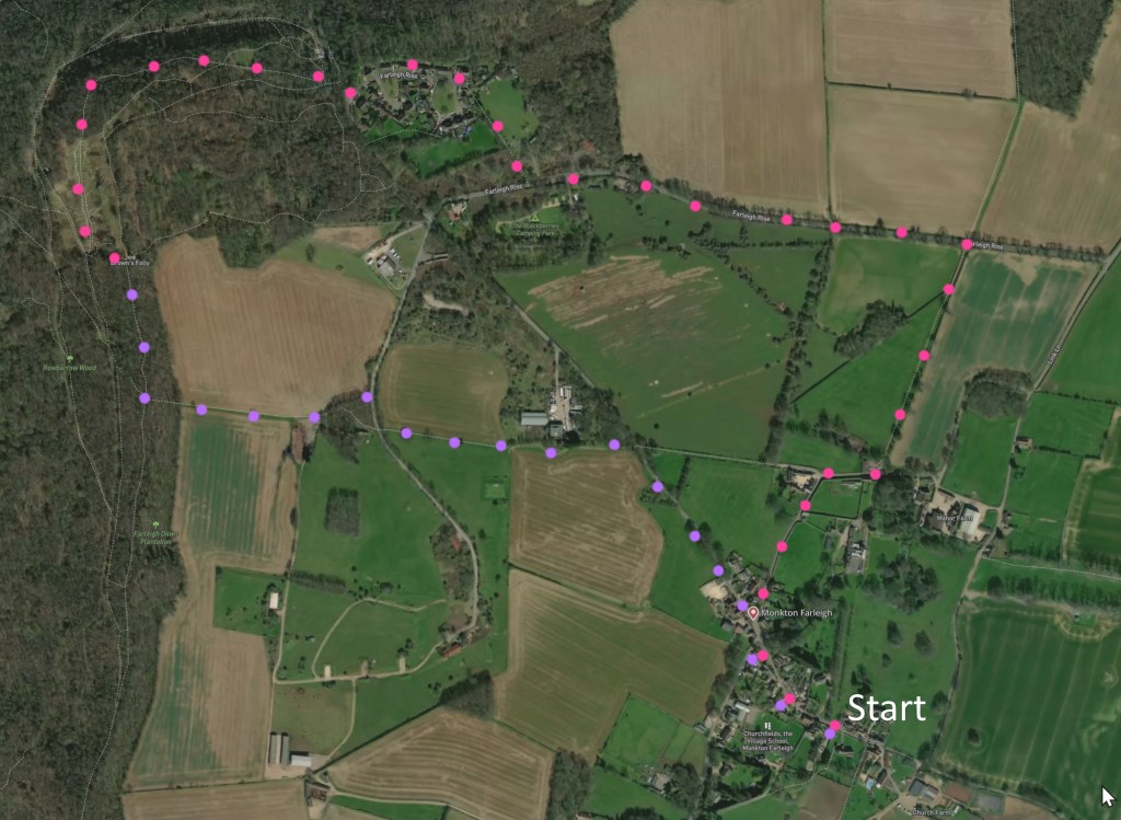
A 3-mile walk around Monkton Farleigh, no stiles, some steps. Click map to enlarge. Very rewarding: great views, ancient and modern historical detail, a folly, and a range of walking landscape. Click here for an aerial view. Click here for PDF download/print. (There is a GPX route option here for phone/tablet download. But only follow this link after watching this GPX help video). Friendly warning: all files relating to walks are published here in good faith but on the understanding that users must be responsible for their own safety and wellbeing.There is an outline of this walk on YouTube
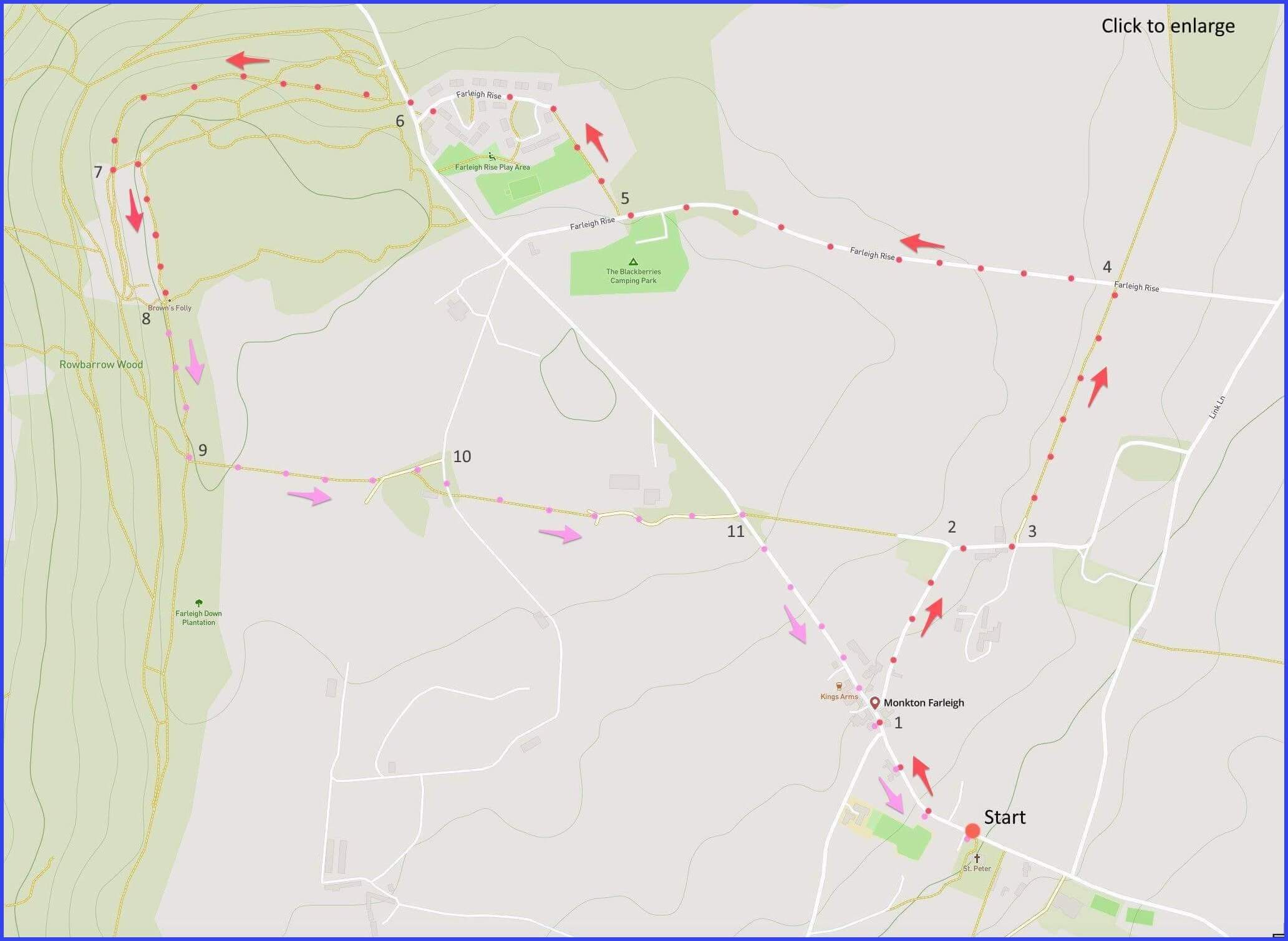
(Routes from map points + metres to next point)
Start From the church, walk uphill passed Manor entrance (on right). 200m
1: Walk right at this road junction opposite old phone box (to Kingsdown). 280m
2: Stay on this lane but follow it round rightwards
3: Opposite another Manor entrance take kissing gate into field path. 90m
4: At gate, leave field and take left onto Farleigh Rise road. 380m
5: Just beyond campsite entrance take bollarded right pathway. Overlook ‘residents’ sign, or stay on road a bit longer if you prefer. 500m
6: Exit it and turn down to the left quickly picking up signed path at gate on left. Several paths go through the wood. Best is slightly to right (head 1 o’ clock). 600m
7: At viewpoint, take steps up to higher path and walk forward. This section has recently been fenced, Follow its narrow path 250m
8: Browne’s Folly. Take path down beside fencing. 260m
9: Take sharp left path with two stone struts at entrance. 300m
10: Turn right on paved road, shortly renewing footpath on left. 400m
11: Join road and head downwards towards start. 530m
The pictures below are in the order things were seen on this walk. Clicking on any one will enlarge it (and the slideshow)
![[A]](https://wiltshirewalks.com/wp-content/uploads/2022/08/monkton01.jpg)
![[B]](https://wiltshirewalks.com/wp-content/uploads/2022/08/monkton02.jpg)
![[C]](https://wiltshirewalks.com/wp-content/uploads/2022/08/monkton03.jpg)
![[D]](https://wiltshirewalks.com/wp-content/uploads/2022/08/monkton04.jpg)
![[E]](https://wiltshirewalks.com/wp-content/uploads/2022/08/monkton05.jpg)
![[F]](https://wiltshirewalks.com/wp-content/uploads/2022/08/monkton06.jpg)
![[G]](https://wiltshirewalks.com/wp-content/uploads/2022/08/monkton07.jpg)
![[H]](https://wiltshirewalks.com/wp-content/uploads/2022/08/monkton08.jpg)
![[I]](https://wiltshirewalks.com/wp-content/uploads/2022/08/monkton09.jpg)
A well-hidden Wiltshire village with a long history flowing from a Norman monastery. Yet beneath the tranquillity of this place lies an unexpected wartime story. The route converges on a whimsical folly visible for miles around – and therefore affording you a fine view of those miles around.
Manor and Church
Here’s a familiar Tudor period tale. First (1125) there was a Cluniac priory (Benedictines: they stress contemplation and resist external management). It was founded by the Norman Baron Humphrey II de Bohun – on his wife’s wishes. The present St Peter’s church served those Cluniac monks. Then in 1536 Henry VIII dissolves all such monasteries. So what should be done with their lands? (Not to mention their monks – but that’s another story.) The answer was to reward the land to powerful gentry. Priory becomes Manor House. Manor acquires new Lord. Lord manages local community.
In this case the land was granted to Sir Edward Seymour, brother of Henry’s queen, Jane Seymour (the only wife to give Henry a son). Thus, Henry’s successor – the child king (Edward VI) – was Seymour’s nephew. So he was appointed the necessary ‘Lord Protector’. After all, Edward was only nine and the country was not in great shape. (Edward’s reign ended with terminal sickness at age 15). The Manor passed through various hands subsequently – including the ubiquitous Longs clothier family, based in nearby South Wraxall (towards which there is a 1.5 mile driveway, starting on the right of the present map – a good walk by the way).
The Longs passed the lease and Lordship of the Manor to Wade Browne (1842). The house was later sold to Sir Charles Hobhouse, 4th Baronet and Victorian MP and it has since stayed in his family. The current owner is old Etonian Sir Charles Hobhouse, 7th Baronet. Its hard to work out what Sir Charles does – he seems to have been some sort of old-school adventurer/explorer. Perhaps a good basis to be appointed in 2022 as the Chief Sheriff of Wiltshire. (This is a post traditionally held for a year and not attracting renumeration.) In any event, he appears a well-intentioned Baronial sort – at the Manor he runs “a wildlife friendly mixed farming estate”
Into the woods
St Peters is the recommended starting point for the walk. It was built alongside the original (and lost) priory church in the thirteenth century. But rebuilt in 1844, although there are some remnants of the earlier period (the Norman north doorway and perhaps the thirteenth century west tower). There is some attractive stained glass to be seen inside (arts and crafts).
Much of this walk takes you down very quiet lanes, a few clear field paths, and the pleasantly deserted Farleigh Rise road. However, look out for the pill box (Type F3/22) on this road – about which more below.
None of the route is difficult but the route through the woods (to the folly) should be taken with care. The paths are clear and wide but there are some steep drops. Be aware there are two sets of steps to get close the folly (take the first): they are not that steep but the route down to your starting point does require you take these steps.
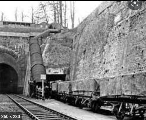
Under the ground
The pill box suggests a military presence – although it was not part of the wartime GHQ Stop Lines. However, there are many more boxes to be spotted in this area. Their presence is a legacy of the use put to a labyrinth of stone quarrying caves during World War II. The extent of local quarrying is depicted in this 1985 map.
In the 1930s it was proposed that three Central Ammunition Depots (CADs) should be constructed: one in the North, one in the Midlands and one (here) in the South. The (related) underground war control area at Corsham is well known locally; less well known is the CAD at Monkton Farleigh. The quarrying tunnels here were converted to war use by thousands of labourers from South Wales, Durham and Northumberland. They were billeted in Bath. A sense of what lies under the ground at Monkton Farliegh is hard to convey briefly. More useful might be this video tour (on your walk, notice various related but decaying ground level structures still standing). If you want a shorter, text version, of this underground world, try this.
This 9-square mile underground area included extensive railways to transfer ammunition to and from the mainline railway. A platform was built at Shockerwick (between Bath and Batheaston) linking to the mainline branch, including a separate entrance to the Box Tunnel (now filled in). The design was such as to ensure that an in-quarry explosion would not propagate. At that time this area beneath your walking feet – beneath this peaceful countryside – was the biggest ammunition dump in the world.
Foolish folly
Finally, the turnaround point of the walk is Browne’s folly (locally known as the Pepperpot). It’s a 1845 tower built by Lord of the Manor Colonel Wade Browne. He seems a decent chap: it was said his folly was to provide local employment during the agricultural recession. He also built a school in the village. And when the Master died, while the church rector took over the boys, Wade Browne took on the girls himself (requiring them to wear red cloaks, blue gowns and white aprons and collars).
The folly is now owned and managed by the Avon Wildlife Trust: it is a Sight of Special Scientific Interest because of rare roosting bats (Bath Asparagus and Stinking Hellebore). However, today the folly suggests foolishness of a more modern, health-and-safety variety. It is fully open and the interior winding stairway has no rails, yet these stone steps can be climbed to the top. Moreover, at the top is an open viewing point that is more than a little bit precarious. After all, the site is hardly reachable by anyone considering a rescue operation. So, rather than climb it yourself, why not take this virtual trip up it instead.
You might want to terminate your walk at the Kings Arms in the village. It has been re-modelled but retains a sixteenth century doorway and 17th-century two-story porch. There is a brewhouse with stone inscription “W.K. 1625”. Pleasant garden and decent menu.
Two updates for this lovely walk: we did it September 2024. Firstly instruction #5: the path after the camp site is on the right, not on the left, of the road. it’s clear on the.map where to go.
Secondly, sadly the pub in the village apparently closed as of February 2024, although it still has an amazing wisteria in the front yard.
Yes, very sad about the pub. And thanks for the correction on the path