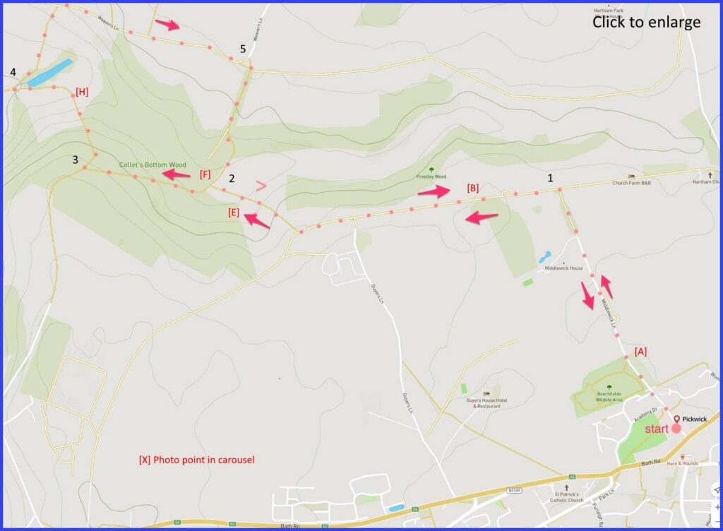
SN13 0HX A 4-mile easy walk around Pickwidk with some parts occasionally muddy and at least one fairly steep hillside Click map to enlarge. Water is blue, wooded green, contour lines show slopes. Click here for aerial view. Click here to download/print PDF. (There is a GPX route option here for phone/tablet download. But only follow this link after watching this GPX help video). Friendly warning: all files relating to walks are published here on good faith but on the understanding that users must be responsible for their own safety and wellbeing.
(Routes from map points + metres to next point)
0: From start walk up Middlewick Lane (pic A) to junction. 900m
1: Turn left. Walk (pic D) past a turning to Pickwick Lodge farm [500m] Then walk a further 275m and drop down a steep slope (pic E) to a bridleway post [250m]
2: At this post turn left and walk through Collets bottom wood (pic G) [closeup map here]. 500m
3: At path T-junction take right path and follow. 270m
4 Follow slightly concealed footpath to your right that runs alongside a field with high hedges to a lane junction [closeup map here]. 290m
5 Walk on this Weavern lane until the sharp left turn upwards but take the footpath down to reach point the bridlepath sign again. 1km
Then retrace your steps to start. 2km
The pictures below are in the order things were seen on this walk. Clicking on any one will enlarge it (and the slideshow)
The walk
There is parking around Middlewick Lane from where this walk starts. The first (and also the closing) part of the walk is flat and straightforward ground. The suggested route passes a number of attractive old farming houses, some of which have adopted an elegant country living look [B]. The second half of the walk is a little more demanding – paths can be somewhat muddy and there are moderately steep inclines to be tackled (e.g. down to point 2 and from points 3 to 4 on the map). But the route is entirely on designated footpaths, and it rewards with good views of pastured farm land. (Be careful not to miss the turning right and upwards at point 4. It’s a narrow-fenced path that joints a paved lane. From point 5 things are easy as the starts to repeat itself – now heading back.
Pickwick
The walk starts in a village with a quirky name – although one that probably suggests the Charles Dickens novel. Dickens actually wrote the ‘Pickwick Papers’ in nearby Bath (largely in the Saracens Head on Broad Street apparently) so it’s not unreasonable that there might be an association of some sort.
It is commonly claimed (in these parts anyway) that he was inspired for the name of this book by the story of a baby who was abandoned in a basket in the village of Pickwick. The hapless boy was named ‘Moses’ (yes – after the biblical prophet found in bullrushes) and then ‘Pickwick’ after the village. The Moses of pickwick prospered. He became a coachman on the Bath London route and, ultimately, ran a coaching business from the Hare and Hounds pub. The claim about a link to ‘Pickwick Papers’ goes on to suggest Dickens stayed at this pub on visits to Bath. This seems possible: after all, it was certainly a staging point on the journey to London – horses would be changed there after the steep climb from Box.
As you go up (and later down) Middlewick Lane you may notice the 18th century Middlewick House. This was formerly occupied by Camilla and Andrew Parker Bowles. But now is the home of Nick Mason (CBE), former drummer with Pink Floyd (on every album – and still (at time of writing) banging on live at 77). Such Wiltshire houses are often occupied by aging rock stars. And sometimes their helicopters get parked there (picture J). Nick occasionally opens his manor for the locals. Perhaps this is all to the good: there could be far less colourful rich owners.


![[A]](https://wiltshirewalks.com/wp-content/uploads/2021/10/01pick-150x150.jpg)
![[B]](https://wiltshirewalks.com/wp-content/uploads/2021/10/02pick-150x150.jpg)
![[C]](https://wiltshirewalks.com/wp-content/uploads/2021/10/03pick-150x150.jpg)
![[D]](https://wiltshirewalks.com/wp-content/uploads/2021/10/04pick-150x150.jpg)
![[E]](https://wiltshirewalks.com/wp-content/uploads/2021/10/05pick-150x150.jpg)
![[F]](https://wiltshirewalks.com/wp-content/uploads/2021/10/06pick-150x150.jpg)
![[G]](https://wiltshirewalks.com/wp-content/uploads/2021/10/07pick-150x150.jpg)
![[H]](https://wiltshirewalks.com/wp-content/uploads/2021/10/08pick-150x150.jpg)
![[I]](https://wiltshirewalks.com/wp-content/uploads/2021/10/09pick-150x150.jpg)
![[J]](https://wiltshirewalks.com/wp-content/uploads/2021/10/10pick-150x150.jpg)
Nick Mason opens his house every July for one weekend in aid of the Air ambulance. He displays some of is extensive car collection and also his helicopter.