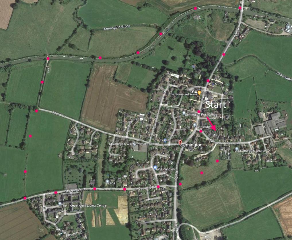
BA14 6JR This is an easy 4 mile walk around Semington. About a third of it is along the Kennet and Avon canal tow path. Click map to enlarge. Water is blue, wooded green, contour lines show slopes. Click here for arial view. Click here to download/print PDF. Friendly warning: all files relating to walks are published here on good faith but on the understanding that users must be responsible for their own safety and wellbeing.
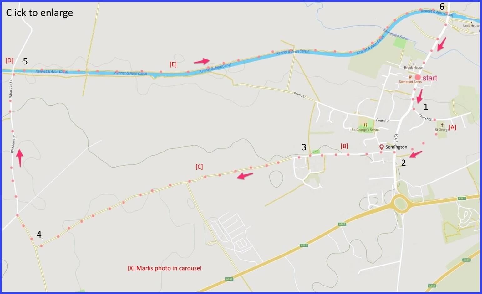
(Routes to take from map points + metres to next point)
1: From High Street head towards Church Lane. Just before church, take the fenceed path and follow line of trees rightwards until it meets road. 500m
2: Turn right and then immediately left onto St George’s Road to Independent Living Centre (once Workhouse). 225m
3: Walk forward until meerting T-junction with similar path. 1.3km
4: Turn right and walk to pick up Whaddon Lane at X-junction. Walk forward to canal. 500m
5: Turn right onto towpath, walk forward until High Street crosses canal. 2.2km
6: Join High Street and return to start. 300m
The pictures below are in the order things were seen on this walk. Clicking on any one will enlarge it (and the slideshow) .
![[A]](https://wiltshirewalks.com/wp-content/uploads/2021/10/01sem.jpg)
![[B]](https://wiltshirewalks.com/wp-content/uploads/2021/10/02sem.jpg)
![[C]](https://wiltshirewalks.com/wp-content/uploads/2021/10/03sem.jpg)
![[D]](https://wiltshirewalks.com/wp-content/uploads/2021/10/04sem.jpg)
![[E]](https://wiltshirewalks.com/wp-content/uploads/2021/10/05sem.jpg)
![[F]](https://wiltshirewalks.com/wp-content/uploads/2021/10/07sem.jpg)
The walk
Parking is easy on Semington High Street. Once leaving the town streets, the route picks up a fenced pathway that runs along the near side of the parish churchyard (but you may like to first inspect that church before joining that path). With the church now behind you and bearing to the right, a short diagonal field path is taken alongside a run of trees. Until reaching the canal, the route is paved. There is a right turn at map point 4 which is followed by a straight route to the canal. The canal towpath is easy and affords viewing plenty of wildlife (and some boats perhaps). You return to the High Street where you might take refreshment in the pub.
Around Semington
This village has been populated since the 12th century. Until a recent bypass was built, it was violated by a constant stream of A350 traffic. It is now a quiet canal village with two ‘Semington Locks’ (from 1794 and 1802) on the Avon and Kennet canal. Once it was the junction point for the start of the Wilts and Berks canal that headed north through Melksham, Chippenham and Swindon into Berkshire. Perhaps if the railways had not come along Semington would have been more of a boom town. However, there is currently talk of re-opening the ‘Melksham Link‘. Although the project repeatedly stalls as, perhaps, its just a little bit fanciful.
Semington is otherwise an unexceptional place, although there are a few old houses of note – Pevsner mentions the 17th century Manor House on High Street. And it is worth checking out St George’s church on your way. It is !5th century, although much rebuilt around 1860. The oldest houses in Semington are on this Church Street, mixed in with pre-war council houses.
You will walk past the old (Grade II listed) St George’s Hospital built in the 1830s as the Trowbridge and Melksham workhouse. After the second world war it served as a hospital for elderly patients. It has now become a centre for independent living, providing residential support for disabled people as well as some high end private accommodation. I guess this must signal progress from a ‘workhouse’ era. Great window [B]
The tow path is a very pleasant walk in the second half of this route, usually with much wildlife in view. You will pass the old Semington aqueduct (1807 and 46 feet long) that carries the Kennet and Avon over Semington Brook. Actually, there are two aqueducts in Semington. The second, new one (2002) was constructed as part of the bypass scheme for Semington. The canal is peaceful and recreational today. Once it would have thrived on the transport of coal from the Somerset coal fields and stone from the loal quarries – perhaps ultimately reaching London.
You might like to finish up at the Somerset Arms. It’s a fair enough pub – with a bit of outdoor seating if the weather fits (Update – this pub is closed – at this time (12/2025). Although there are plans to recover it).
Great walk, but please note that the Somerset Arms pub is currently closed – the village is looking to buy the building for renovation and reopening as a community hub
Ah, too bad another closed pub. Thanks for the news. I will amend