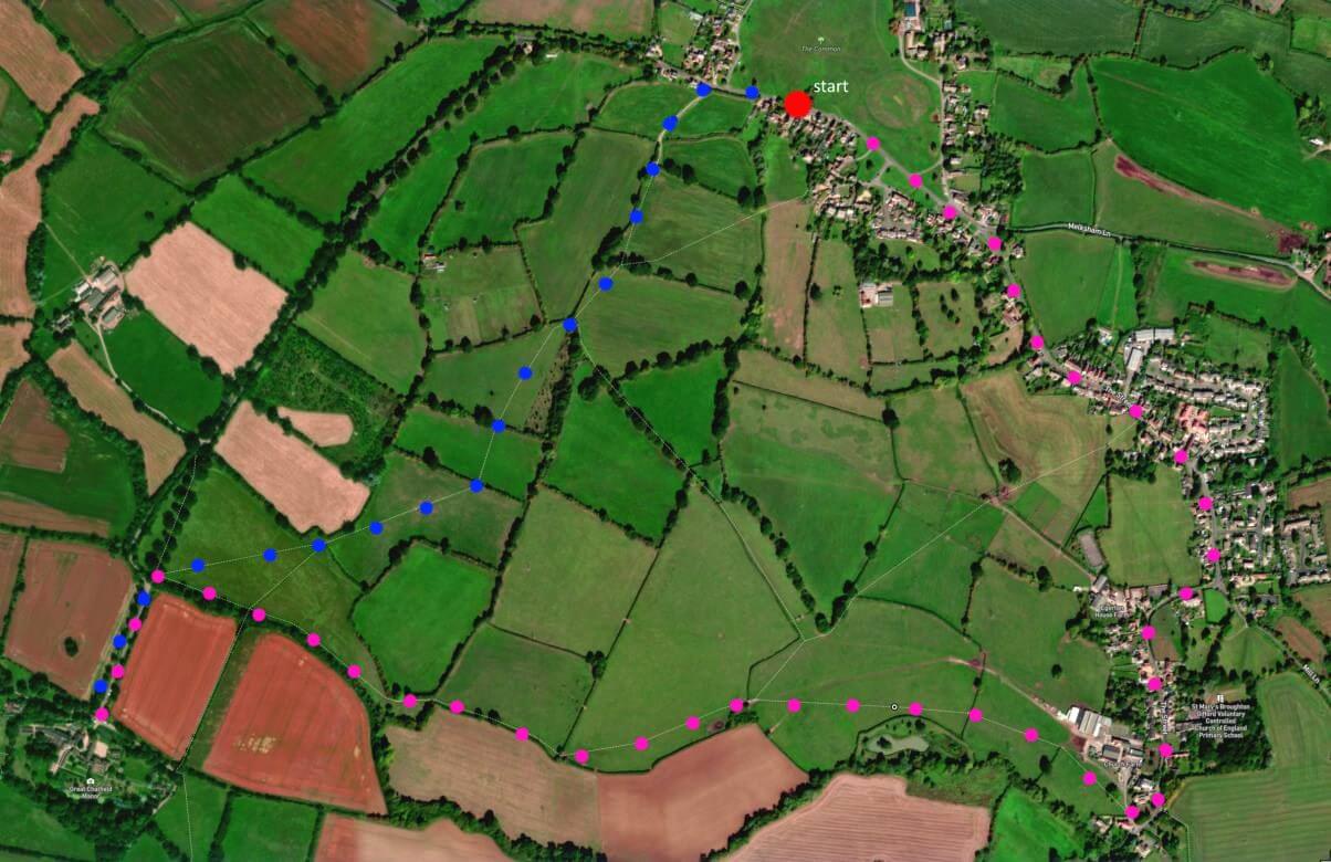
A 3.5 mile walk around Broughton Gifford, largely field-based, flat with a couple of stiles towards end. Strikingly quiet. Manor house visit possible. Click map to enlarge. Click here for an aerial view. Fieldpath numbers indicate stiles or gates. Click here to dowload/print PDF. (There is a GPX route option here for phone/tablet download. But only follow this link after watching this GPX help video). Friendly warning: all files relating to walks are published here on good faith but on the understanding that users must be responsible for their own safety and wellbeing.
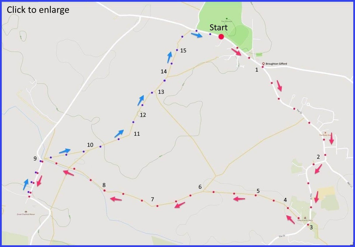
(Route from map points + metres to next point)
Start: Park alongside the common. Walk past Bell pub towards ‘The Street’. 90m
1 At this Y-junction take right fork (The Street) through village to Manor House Y-junction [A]. 750m
2 Follow road to right round towards parish church [B]. 475m
3 Through churchyard to a gate to the road at the base of the church grounds. Cross road to a field gate opposite. Enter and walk forward to right corner of field and holiday homes. 200m
4 Walk rightwards towards a gate in centre of field boundary oppositve you. 170m
5 Walk diagonally leftwards across large field towardsd exit point in far left corner [C]. 380m
6 Walk towards the far left corner of the boundary in front of you for this large triangular field. 320m
7 Walk the left boundary of this square field to the leftmost point of its boundary. 215m
8 PIck up and follow walk alongside river of left boundary until exit to lane. 550m
9 Exit onto this road and turn left towards Chalford Manor. Visit? Return. 500m
9 Re-enter field at point 9, ignore tree-lined route to left. But follow centre 45 degree angle path across field to exit into next. 290m
10-15 Again diagonally to stile in middle of next field boundary. Thereafter walk straight towards village. Map shows stile/gate points leading back to final short path into the village and main road. 1.1km
The pictures below are in the order things were seen on this walk. Clicking on any one will enlarge it (and the slideshow)

![[A]](https://wiltshirewalks.com/wp-content/uploads/2022/05/A.jpg)
![[B]](https://wiltshirewalks.com/wp-content/uploads/2022/05/B.jpg)
![[C]](https://wiltshirewalks.com/wp-content/uploads/2022/05/C.jpg)
![[D]](https://wiltshirewalks.com/wp-content/uploads/2022/05/D.jpg)
![[E]](https://wiltshirewalks.com/wp-content/uploads/2022/05/E.jpg)
![[F]](https://wiltshirewalks.com/wp-content/uploads/2022/05/F.jpg)
![[G]](https://wiltshirewalks.com/wp-content/uploads/2022/05/G.jpg)
![[H]](https://wiltshirewalks.com/wp-content/uploads/2022/05/H.jpg)
The walk
Parking is straightforward on the edge of the Common. The village is quite large – mainly stretching down the road that forms the first part of this walk. Most of the route is across fields: much silence but little livestock. It is all fairly flat but there are number of stiles that have to be taken on. Nothing strikingly difficult though. If you have time (and entrance fee and it’s a day they open) then Chalfield Manor at the half way point is a special reward.
BG: the village
The village was first mentioned in a 1001 charter although, as ever, Roman coins etc have been found hereabouts. In the 16th and 17th centuries it was an important place, with employment centred around cloth and weaving, as well as agricultural workers (the land has always been good for pasture). BG also had some reputation for the rearing of geese. Local menfolk were sometimes known as ‘Broughton Ganders’. The village had a go at exploiting its mineral springs, but these were no more successful than Holt or Melksham (blame Bath). In the later 18th century domestic hand loom weaving gave way to mechanisation and local workers would take the long canal walk to Bradford – sometimes having to sleep overnight on the factory floor. Lately it’s a comfortable mid-size village, seemingly thriving and prosperous. Although how does a community thrive with one pub and no village shop (answer here)?
Walk: the road
At first sight BG seems to be just a small settlement around a Common (one that escaped 18th century enclosure). But most living is actually on a residential ‘tail’ extending south from here as ‘The Street’. This celebrates the kind of straggling ribbon development loathed by planners. The walking starts at (and could end inside of) the Bell on the Common: a short line of houses, transformed into a pub around 1782. The Street introduces the village proper. First, branch right at the war memorial commemorating 148 men from WW1 (sadly, 23 didn’t return) and six from WW2 (none returned). Shortly, on your left, should be The Rusty Stag: a row of three 17th century rubble stone houses that became a gourmet pub. Currently (2022) its closed. Probably another pandemic victim. Spot the weavers cottages along this stretch.
There was a shop in the village once: it was the ‘General Store’ on the right at number 10 (bright red bricks facing south). Then comes the Manor House at the roadway Y-intersection [A]. It was built in 1620 (subsequently extended) probably for Sir John Horton who shifted from cloth into land: steep gables and mullioned windows. Until 1962 it was the home of playwright Clifford Bax, brother of composer Arthur Bax – their uncle was the Victorian socialist Ernest Bax. Clifford appears to have been a keen cricketer and the ‘New Bax Broughtonians’ still seem active. Finally, on the left, comes the CofE St Mary’s School: about 70 kids. Built in 1853 on the site of an older school: one set up in 1782 from charity money “for instructing 20 poor boys and girls”.
Don’t bear left at this fork (Mill Lane) but if you did you would reach the 1906 railcar line where a Broughton request stop once existed on the Chippenham/Trowbridge route. The Stop was closed in 1955 although the single track still occasionally carries traffic.
Before leaving the road for the fields you discover the 13th century St Mary’s church [B]. If not shut (it probably is), it deserves a look. Among the memorials is one (1620) to a member of the ubiquitous Wiltshire Long family. It offers a whimsical poem starting: “The life of man is a trewe Lotterie…..”. Quite so. Cross the church yard and head to the fields.
Walk: the fields
Perhaps this walk seems too flat and plain but what is striking is the refreshing silence. This area was once extensively cultivated but now is pasture. Yet surely the sequence of empty fields raises (post-Brexit) questions of why there is such a lack of visible farming. Of course one modern option for such land is solar farms. BG has awkwardly engaged with this idea – around its northern boundary at Norrington. The owner of the £3.5m, Commons-facing, Grade II* listed ‘Gifford Hall’ objected to the Norrington solar farm on the apparently selfless grounds that it would “ruin the local landscape for future generations” (a landscape generously covered with planning notices that the litigant failed to see). His overdue appeal was quashed and then denied to the Supreme Court. Yet the affair animated some unwelcome NIMBY publicity that stretched all the way from the BBC to the Daily Mail.
Chalfield Manor
Before heading back over these gentle fields one might visit Chalfield Manor [H]. Check opening – and being a member of the National Trust will help. The house (15th century – timed tours), the integrated church (1480), and the Arts and Crafts garden (video) are all splendid.
The house was created by Thomas Tropenell (1405-88), although with some later Edwardian reconstruction. Tropenell illustrates a break in the traditional pattern of manorial ownership. In the Middle Ages, ownership might be most often associated with the church, knightly status, or noble lineage. But Tropenell appears to have been of relatively humble origins. His social standing arose from his training in law and the patronage of the local baron Lord Hungerford – who Tropenell advised (over three generations) on matters of estate management. So Tropenell may represent the emergence of the ‘Tudor Gentleman’ – a landowner whose manorial status owed more to confidence with the pen than with the sword. And thus a trajectory of diversity in ownership came into being.
Retrace steps and head back through the fields (note the alley of oak trees in first field – once part of a route to the Manor).