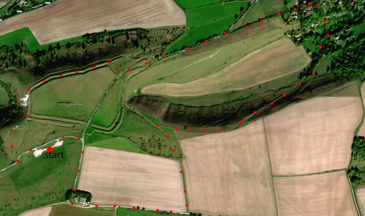
From BA13 4TA a 3.5 mile walk around Westbury Horse starting from car park – with no stiles but steep (yet secure) incline in middle part. (Click map to enlarge. Click here for an aerial view) Click here to download/print PDF. (There is a GPX route option here for phone/tablet download. But only follow this link after watching this GPX help video). Friendly warning: all files relating to walks are published here in good faith but on the understanding that users must be responsible for their own safety and wellbeing.
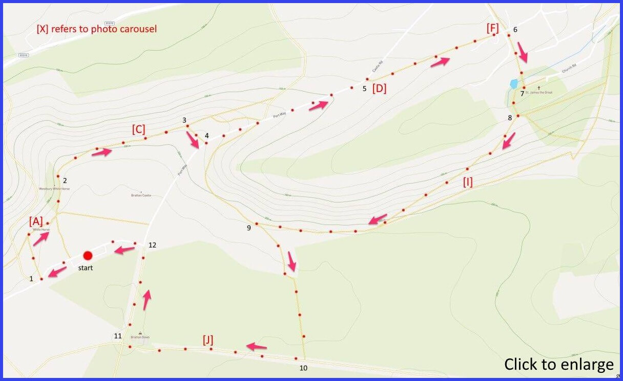
(Route from map points + metres to next point)
Start: From car park, walk downwards to the second gate on your right leadding into field. 100m
1 Walk down towards trees and head right on path towards viewing point. Then follow path that runs above (but close to) the horse [A]. 250m
2 Putting the horse behind you, follow level chalk path until you reach a path junction on your right. 420m [C]
3 Take the short path up to the right that leads to a track (Port Way). 90m
4 Turn left on this track and head down hill until you reach a Y-junction with Castle Road going off to left. 1km
5 Instead, take footpath entrance to your right that continues your path downwards towards village, joining Port Way [D]. 470m
6 Turn right onto Combe Lane. Dont take the cul-de-sac, but the parallel footpath just above it going towards church [F]. 150m
7 Admire church and its surrounds then exit uphill taking rightwards direction from the churhyard [I]. 200m
8 At this point take the path that heads you diagonally up the steep slose in front of you and heading back towards horse area summit. 880m
9 At a gated junction. Go through gate and take path at right angles to you to join a gravel roadway. 360m
10 Take the right direction here, walking alongside an army field towards farm buildings [J] 350m
11 At these buildings, turn right and walk forward on Port Way. 200m
12 Take a left turn of this lane and head towards car park and your start. 250m
The pictures below are in the order things were seen on this walk. Clicking on any one will enlarge it (and the slideshow)
![[B]](https://wiltshirewalks.com/wp-content/uploads/2022/04/B.jpeg)
![[C]](https://wiltshirewalks.com/wp-content/uploads/2022/04/C.jpeg)
![[D]](https://wiltshirewalks.com/wp-content/uploads/2022/04/D.jpeg)
![[E]](https://wiltshirewalks.com/wp-content/uploads/2022/04/E.jpeg)
![[F]](https://wiltshirewalks.com/wp-content/uploads/2022/04/F.jpeg)
![[G]](https://wiltshirewalks.com/wp-content/uploads/2022/04/G.jpeg)
![[H]](https://wiltshirewalks.com/wp-content/uploads/2022/04/H.jpeg)
![[I]](https://wiltshirewalks.com/wp-content/uploads/2022/04/I.jpeg)
![[J]](https://wiltshirewalks.com/wp-content/uploads/2022/04/J.jpeg)
The walk
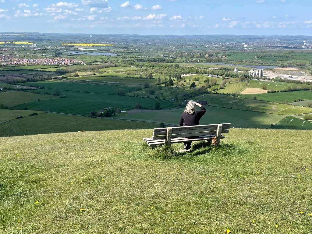
Spectacular views, ancient hillfort, closeup to a Wiltshire white horse, Site of Special Scientific Interest, postcard church… what more could a walker ask for? The only challenging part is the incline half way along, But what goes down [D] must come up [I]. It is certainly a steep climb (and deserves care on the steep descent). However, the views are stunning. There is a car park well signposted right next to the horse’s area.
White horse
It really ought to be the “Bratton White Horse” even if it does overlook Westbury. But maybe that little market town will be better known to Great Western rail travellers – whose gaze the horse easily attracts. It’s the oldest of the Wiltshire hillside horses, has the best tail, and is the only one depicted standing still. Although like the others (excepting Devizes) it faces left. How is that choice made? Perhaps that’s the way most people would draw a horse? Although a horse in motion might look more comfortable heading left to right. Pevsner (surely no authority) comments a “moderately correct, if dispirited animal”.
The present horse owes its appearance to George Gee (well named), working in the service of Lord Abingdon in 1778. Evidence suggests that a much older horse already existed which Gee didn’t think look convincing. In 1873 it was further ‘rectified’ and in 1957 the outline was filled with concrete. The sad fact is that a genuine chalk horse is hard to maintain. Although even concrete must be regularly cleaned. For example, in 2003 the message “stop this war” was written across it in resistant yellow paint. As it happens, it is due another “biggest overhaul” in 2022 – with English Heritage testing for a more sustainable white paint. After all, easy access makes it attractive to visitors and there is something compelling about its image (Midge Ure featured it in a barmy music video for his song ‘Breathe’)
Bratton camp/castle
There is a view that the original white horse installation was to celebrate King Alfred’s victory over the Danes in the ninth century. It must have seemed a good spot to make a point – facing west to the setting sun. Some historians believe this considerable triumph (the battle probably centred on Edington) was a turning point in European history. At least in terms of firming up English identity. The Danes are said to have held out at the iron age hillfort above the Bratton horse. When they finally called for peace they also agreed to sign up for Christianity. The ‘camp’ as an important historical site is much older: it was occupied before Roman times – for the hill has been found to include a neolithic barrow over 2000 years older than that.
The camp’s more recent history includes a 1985 lengthy occupation by 2000 New Age Travellers’ in a ‘Peace Convoy’ – they had been denied access to Stonehenge for summer solstice celebrations, where the ‘Battle of Beanfield’ had been a violent rejection of their presence. Retreating to the Bratton camp alternative, things became pretty toxic – police sealed it off and so prevented access to food and water. It morphed into a temporary festival (lead act: Hawkwind – more details here). However, the Convoy’s threatened return to Stonehenge for the Solstice was finally undone by a mad downpour of rain. The larger context – archaeology, culture, politics, druids – is well presented here.
Bratton St James
The church is oddly raised above (and slightly beyond) Bratton village but that adds to its picturesque quality. There is a Norman font, a set of bells, and an unusual sundial on the south exterior – with a particularly long shadow and the phrase “tempus fugit”. Definitely worth a visit. As is the whole area. It’s a site of Special Scientific Interest noted for chalkland plants and animals including “a wide range of herb species and many species of grasses”. A good sense of the whole piece is given by this video.