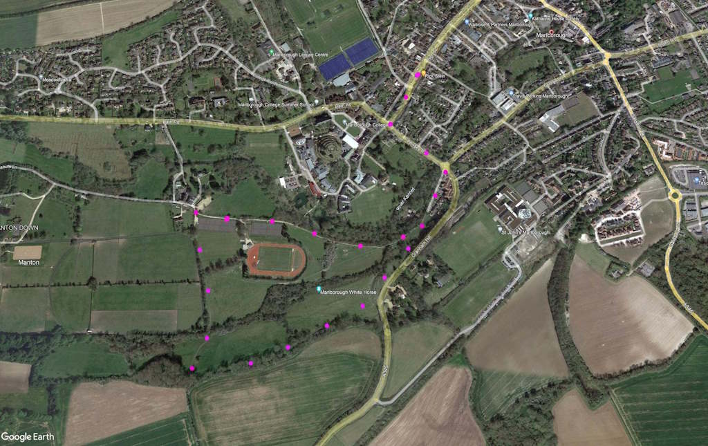
SN8 1NU A 2-mile walk around Marlborogh. Start from town car park. Some awkward rough ground and slopes but all marked paths. Click map to enlarge. Click here for arial view. Click here to download/print PDF. (There is a GPX route option here for phone/tablet download. But only follow this link after watching this GPX help video). Friendly warning: all files relating to walks are published here on good faith but on the understanding that users must be responsible for their own safety and wellbeing.
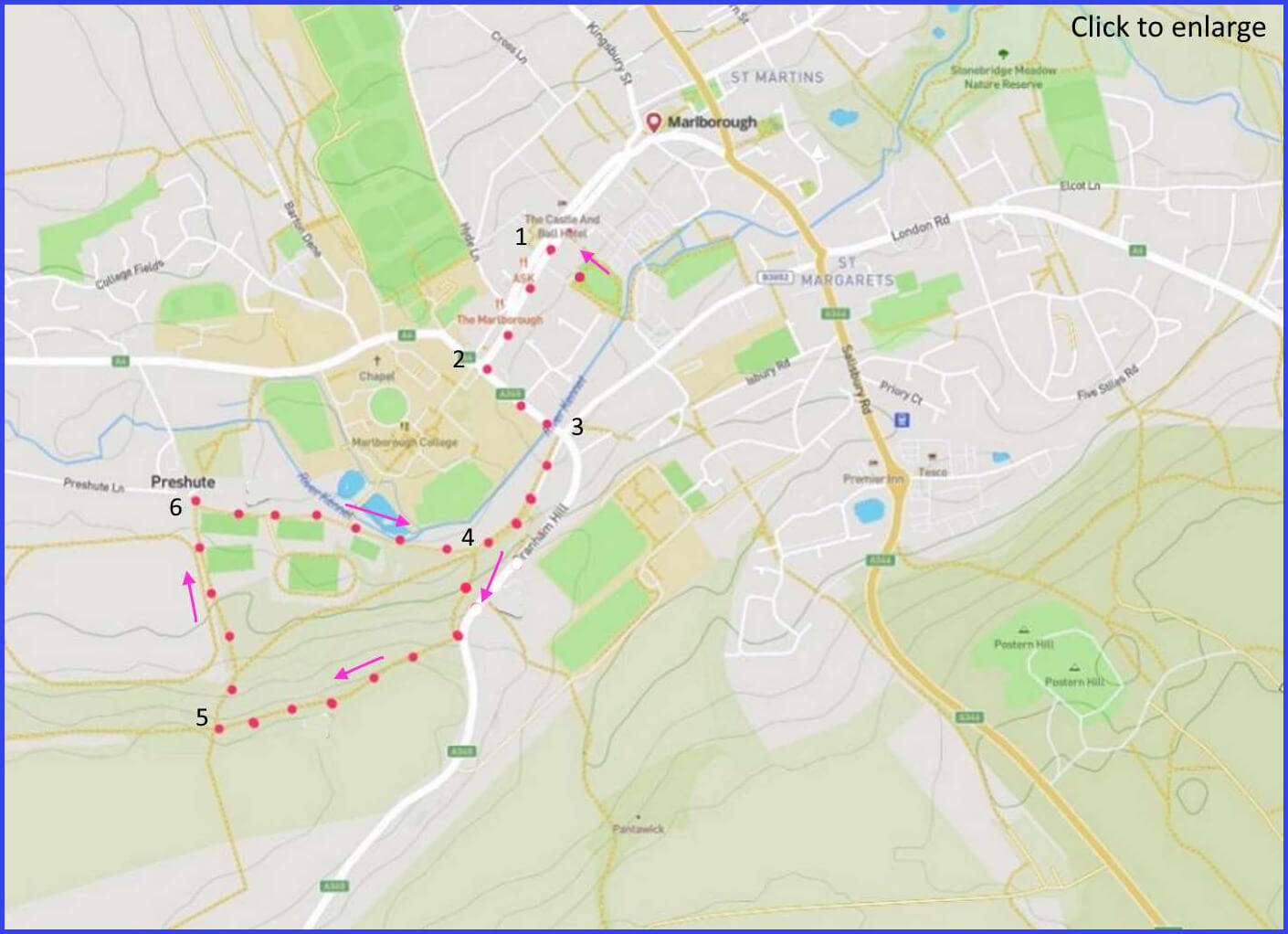
(Routes suggested from each map point + metres to next point)
1: Walk from car parks to main street. 120m
2: Turn left, walk towards school (picture A). 420m
3: Turn right on main road walking first lane then path to a junction of footpaths at the opening of a field 320m
4: Take the left path (of three) that takes you uphill through and alongside a wooded area, reaching a gate close to the road. At this point continue straight alonside the wooded edge of two fields until reaching a route downhill. 900m
5. Take this rough path down slope (White horse trail, pic F) to footpath junction. 420m
6: Turn right and walk along tennis court footpath. White horse is on hill to right – return to your starting path and town. 1km
The pictures below are in the order things were seen on this walk. Clicking on any one will enlarge it (and the slideshow)
![[A]](https://wiltshirewalks.com/wp-content/uploads/2021/10/01marl.jpg)
![[B]](https://wiltshirewalks.com/wp-content/uploads/2021/10/02marl.jpg)
![[C]](https://wiltshirewalks.com/wp-content/uploads/2021/10/03marl.jpg)
![[D]](https://wiltshirewalks.com/wp-content/uploads/2021/10/04marl.jpg)
![[E]](https://wiltshirewalks.com/wp-content/uploads/2021/10/05marl.jpg)
![[F]](https://wiltshirewalks.com/wp-content/uploads/2021/10/06marl.jpg)
The walk
The rewards of this 2-mile route are a chance to look at a distinguished Wiltshire town, a sense of its famous School, a short fieldpath walk, and a sighting of another Wiltshire White Horse. From the town car park, turn left on the main street and walk towards the school. Left again and enter a footpath near the river bridge. A field walk follows. The paths not very strongly marked so follow the general direction of the map and improvise if necessary. At map point 5, drop down a steep incline to reach a point where a right turn will take you past the school buildings and back onto the path you started with.
The town
There is a useful short history of the town here. Marlborough is centred on a very wide and long High Street. It’s claimed to be widest in England, but it’s not; that’s in Stockton. The town is bisected by the A4 or ‘Old Bath Road’. This was once important to the town’s prosperity because of its role in the coaching trade. But the arrival of the Great Western Railway undercut that. However, with the growth of private motoring the town continued to service passing travellers, but the volume of such traffic became overwhelming. With the building of the M4 the town reverted to a rather more sleepy state. One that it enjoys now.
Marlborough seems to have started with the Normans, who built a castle on what was an existing prehistoric mound. It was made a borough in 1204 by King John and its castle was a site of parliament in 1267 (Henry III). That castle is, sadly, lost. There are a couple of churches – one at each end of the High Street. Cardinal Wolsey was ordained in the St Peters one (you pass it) but now it has been made into a cafe. Pevsner says the most interesting High Street building is The Merchants House (towards the far end and on the left) He comments that it represents: “the high style of post-fire rebuilding“. Also boasting “a late 17th century stained glass sundial”. While inside: “the survival of so much fictive decoration gives a rare insight in to the taste of the middling rich“. It can be visited.
A great fire wiped out much of the town in 1653. However, Cromwell organised a national subscription for its rebuilding but, unlike London, it was rebuilt in timber – so inevitably there were later fires. It was after the fire that the High street was rebuilt to be so wide. So a road that became a big market. Now a road that’s become a big car park. But at least that keeps the high street shops alive.
The school
Marlborough College (1843) is the dominating institution in this town: a very successful public school. Fees currently around £39,930 per annum. Although, awkwardly, the Times exposed them in 2005 to be one of 50 private schools found running an illegal price cartel. More commendably perhaps, the school was the first (1968) of the major boys public schools to admit girls into the sixth form (e.g., Kate Middleton and Ghislaine Maxwell). See some more of them here. Sadly, the fabric of this school is not integrated into the town at all. However, you do get a sense of its premises on the route of this walk. It occupies the land that was once the Castle. Deep within its campus (on the right of your path and just beyond/below the White Horse) there is “The Mound“. This is now understood to be neolithic. It is famed to be the burying place of Merlin. Well, maybe. Who knows for sure.
The horse
In the later part of the walk, you will catch a glimpse of the smallest of Wiltshire’s 8 white horses (1804). It was originally carved out by pupils from Mr Greasley’s Academy on the High Street (now the Ivy House Hotel). Until Greasley’s school was closed (1830) his pupils would clean it up every year. You can’t get that close these days – but this video may compensate. Now cleaning duty has been taken over by the College. The boys (and the girls no doubt) spruce up the horse regularly, perhaps for fun, perhaps for punishment. Who knows, all is hidden.
Thanks for comment. And points taken. I think I can work out where the field obstacles might lie. I did this walk some time ago and I suspect things have simply overgrown. Not much of ann excuse though. I will review and amend.
….Later: I now notice the main map and the ariel view are slightly different. That reflects me changing the main map to avoid that dangerous road (for the reasons you rightly give). But i didnt change the ariel map. I have made the change now. One other point: when i changed direction i did not change the PDF download file. Big mistake. You must have been using it. Sorry! Changed now. I cant do much about the nettles etc but i hope any furture walker will appreciate avoiding the road as now directed. Thanks again..