SN14 7DG This is a 4 mile walk around Biddestone = a Full English Village. Some wooded paths may be muddy and some path incline. Click here to enlarge map. Water is blue, wooded green, contour lines show slopes. Click for here arial view. Click here to download/print PDF. (There is a GPX route option here for phone/tablet download. But only follow this link after watching this GPX help video). Friendly warning: all files relating to walks are published here on good faith but on the understanding that users must be responsible for their own safety and wellbeing.

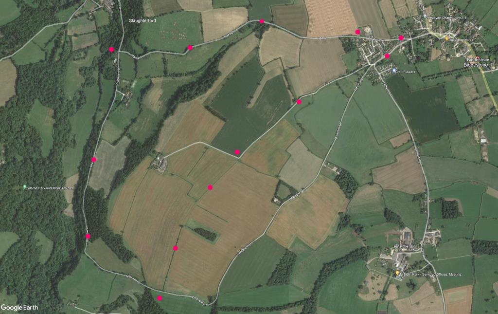
(Routes suggested from each map point + metres to next point)
0: Walk from the village green on Church Road. 200m
1: At the Y-branch, take the right labelled Challows Lane (becomes Ham Lane) and walk to T-junction with Weavern Lane. 1.9km
2: Turn left into this Lane which quickly becomes wooded (pic G). Walk forward. 1.9km
3: Find a footbath entrance on your left gives to a large field (pic H) leading to lane gate. 950m
4: Field Barn Lane leads you back to a road junction. 1km
5: Join ‘The Butts’ and walk along houses to start. 450m
The pictures below are in the order things were seen on this walk. Clicking on any one will enlarge it (and the slideshow)
![[A]](https://wiltshirewalks.com/wp-content/uploads/2021/10/01bidd.jpg)
![[B]](https://wiltshirewalks.com/wp-content/uploads/2021/10/02bidd.jpg)
![[C]](https://wiltshirewalks.com/wp-content/uploads/2021/10/03bidd.jpg)
![[D]](https://wiltshirewalks.com/wp-content/uploads/2021/10/04bidd.jpg)
![[E]](https://wiltshirewalks.com/wp-content/uploads/2021/10/05bidd.jpg)
![[F]](https://wiltshirewalks.com/wp-content/uploads/2021/10/06bidd.jpg)
![[G]](https://wiltshirewalks.com/wp-content/uploads/2021/10/07bidd.jpg)
![[H]](https://wiltshirewalks.com/wp-content/uploads/2021/10/08bidd.jpg)
The walk
Parking is possible in the village, although a little scarce. The first part of the walk is along paved Ham Lane. It becomes increasingly charming before meeting a junction for turning left into Germain’s Lane. That becomes Weavern Lane, running parallel to the River ByBrook. In certain weather this can be muddy. At about the half way point, a left path off Weavern Lane takes you (at a slight incline) across the boundary of two fields to join Field Barn Lane that then it goes back to the village passing a farm.
The village
This village has not been voted the prettiest village in England (that claim belongs to nearby Castle Combe), yet it’s certainly pretty. In many respects it is a prototypical, biscuit tin English Village – with houses gathered around the village pond (no house later than 1700). Add to this the fifteenth century church, the Manor house, a cricket club, and a local pub in the centre of it all. It even used to have a hunt.
The village is of Saxon origin (4 dwellings noted in the Domesday Book). By Norman times it had two manor houses and two churches. Now, most buildings are late eighteenth century, probably reflecting clothier and agricultural prosperity in that period. There are some sixteenth century houses on Cuttle Street.
The village is best known for a much photographed and ancient village pond with its large number of over-fed ducks. Watching ducks eat stuff thrown towards them seems to be satisfying to humans. Thanks to some sort of shared understanding among us, the chosen ‘stuff’ is usually bread. Although evidence suggests that this is bad for ducks. On the other hand, humans are less likely to be carrying those items that are good for ducks (biologists suggest sweetcorn, lettuce, peas, oats, rice). Try and arrive well equipped. Or simply watch the ducks feed themselves.
The church
St Nicholas Church (you pass it on your right before Challows Lane) is modest – although it boasts a fine 300-year old oak door. The building is most notable for its unusual stone bell turret (1480). The Sanctus bell was rung three times a day so that workers unable to attend a service could cross themselves instead. Inside there are some eighteenth-century high box pews. There is also an unusual gallery at the west end. This was built to house the folk from neighbouring Slaughterford whose own church had been destroyed by over-excited Cromwellian troops on their way to Ireland. A gallery was necessary (stairs now gone) because the two communities did not get on that well. Biddestonians apparently resented their intrusion. While those from Slaughterford might have been in a foul mood over the 2-mile walk involved.
Some say the graveyard is haunted by a man dressed in black. He is believed to have been hanged in or around the church.
The walk down Ham Lane is quite steep but affords good views of the surrounding countryside (pic 3). The subsequent walk through woods can be a bit challenging under foot after wet weather [G]. It runs alongside the River ByBrook which forms a rough boundary to the parish. ByBrook was once an important river for the wool trade in these parts providing fast and clear water for the mills. It’s not clear how far Biddestone was part of this trade – although there is an Old Wool House on the Green.