SN10 2HZ A 4-mile walk around Roundway. Over open farmed fields, some light mud tracks. Fairly flat. Some historic sites attract visitors. (Click map to enlarge. Click here for an aerial view) Click here to download/print PDF. (There is a GPX route option here for phone/tablet download. But only follow this link after watching this GPX help video). Friendly warning: all files relating to walks are published here on good faith but on the understanding that users must be responsible for their own safety and wellbeing.
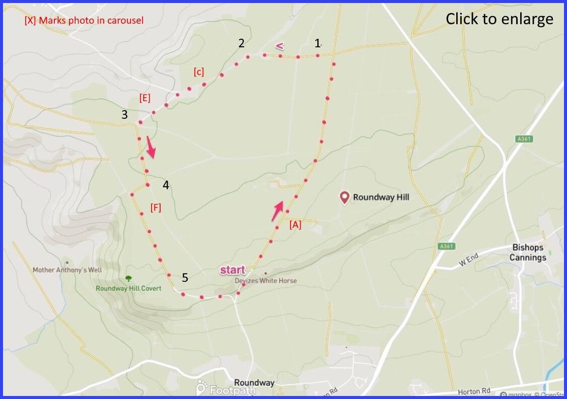
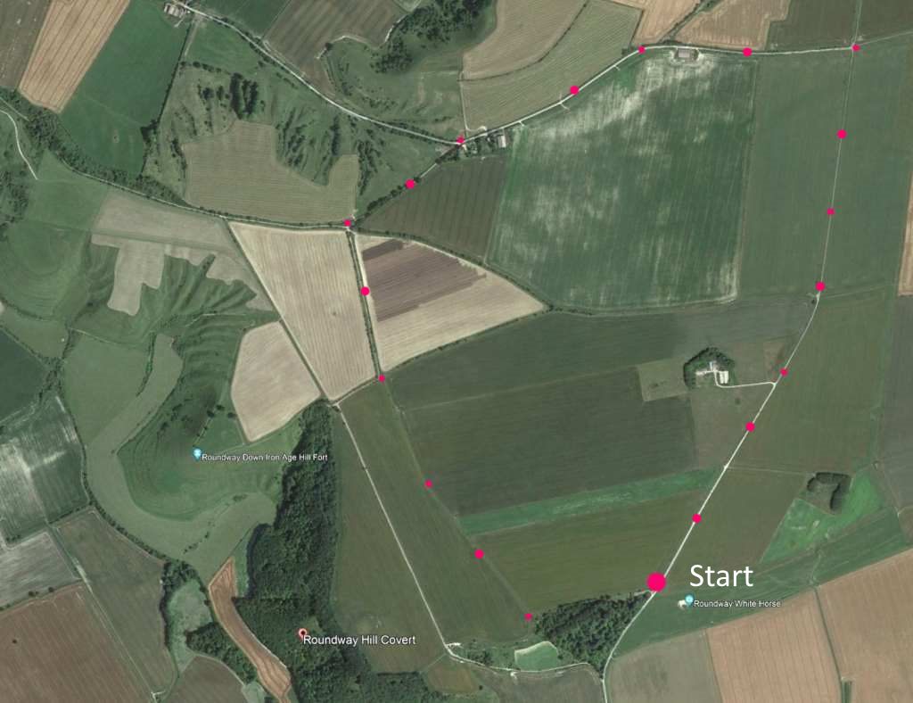
Start: From the car park walk straight on the path [A] away from horse until a path T-junction. 2km
1: At that crossing of paths turn left and follow the path towards farm buildings. 650m
2: At this bend, veer leftwards and walk to a group of farm buildings and a Y-junction take the left fork to a path intersection. 1.1km
3: At this junction talke the left fork lying at right angles to your previous path, walking towards a right angle junction. 490m
4: Take the sharp right. Here you can walk around the hill fort or (as the map shows) take a right and then a left turn, walking parallel to the hill fort. 1km
5 Here the expected route is to take a triangle down and up (steep!) on the path. But you can cut across the third side of the triangle on a pathway through the “Leipzig plantation” and to your start – which is better. 700m
The pictures below are in the order things were seen on this walk. Clicking on any one will enlarge it (and the slideshow)
![[A]](https://wiltshirewalks.com/wp-content/uploads/2021/10/01round.jpg)
![[B]](https://wiltshirewalks.com/wp-content/uploads/2021/10/2round.jpg)
![[C]](https://wiltshirewalks.com/wp-content/uploads/2021/10/03round.jpg)
![[D]](https://wiltshirewalks.com/wp-content/uploads/2021/10/04round.jpg)
![[E]](https://wiltshirewalks.com/wp-content/uploads/2021/10/05round.jpg)
![[F]](https://wiltshirewalks.com/wp-content/uploads/2021/10/06round.jpg)
The walk
If you are driving, the start point for this walk is tricky to find. From the London road heading north out of Devizes, take the left fork at a TravelLodge. Go straight on (‘Folly Road’) passing an aeronautics factory on your right. At an old red phone box, bear right off Folly Road and head upwards to a car park. Here is the local White Horse: looking down onto the Roundway village from the side of its hill. The walk is mainly flat paths and quite level except for the final return to the parking area (unless you take the Leipzig plantation route, as advised in notes.
White Horses
There was once an 1845 white horse just around the hillside corner from this one. But it became increasingly less visible and so drifted from local memory. That is until traces were accidentally noticed and remarked upon in the 1950s. This original beast was known as “Snobs’ Horse”, having been impulsively cut by town shoemakers (termed “snobs”) during a Whitsuntide outing. After which they rather lost interest in the project. In 1999 it was decided (through a newspaper campaign) to make a replacement (volunteer effort), which was grandly named the ‘1999 Devizes Millennium White Horse‘ – making it the most recent of the Wiltshire horses and also the only one facing right.
This matter of ‘facing direction choice’ is interesting: how do the hillside artists chose a direction? Horse-in-motion might imply depicting the profile from left to right (cf. direction of writing). Which then might imply that all the left-facing horses were thought to be stationary. Or maybe the first white horse just happened to be carved out left facing and so all subsequent ones respected that tradition. Anyway, you can go and stand on this one and think about it – although close up its a bit disappointing: seems like it needs a freshening up of the white coat – sadly, rather like the millennium, it’s a faded item.
Civil war battle
The first, long, straight part of this route takes you through the site of Roundway Down. A pleasingly peaceful place and so hard to imagine it as the site of a key battle (1643) in the English Civil War. The Royalist victory (unexpected) allowed their force to move towards London more confidently (a dream squandered however – in the longer run it’s not clear that they took significant advantage).
The path walk has Roundway Hill Covert on your right. Sir Ralph Hopton’s Royalists were garrisoned in Devizes, threatened by Cromwell’s troops but waiting reinforcements from Oxford. When Sir William Waller’s parliamentarians realised that danger, they rose up to this hill in order to anticipate the threat of arriving support. Yet the Royalists, although heavily outnumbered, attacked first and pushed the parliamentarians over and beyond to Olivers Castle (although Cromwell had no part in this exchange). The steepness of its slope did them no favours. The ground at the bottom where many of them and their horses fell is still known as the ‘bloody ditch’. At point 4 you get a view (here nicely filmed from above) of the iron age (600 BC) hill fort that is this ‘Olivers Castle’ – the sorry place that proved fatal for the parliamentarians in this battle and provided the Royalists with arguably their most successful victory (and, moving on, control of the port of Bristol). But in the longer run….
Crop circles
In August 2021 a crop circle was reported around this area (remember them?) – even though it was documented merely 5 days after the above photos were taken, it certainly wasn’t visible on ground level then. Your final return to the starting point threatens to finish on a steep road slope. This could be avoided by cutting through the Liepzig Plantation – named in honour of the 1813 Napoleonic battle (an odd dedication as England was, unusually, one of the few European nations who didn’t join in).