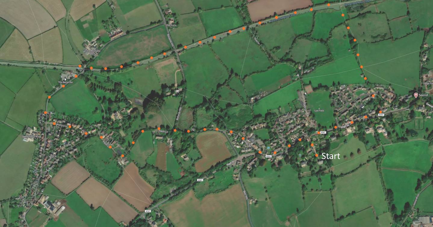
Click map to enlarge. Click here for an aerial view. A 3-mile walk around Seend, no stiles, modest field slope at end. (Limited) parking against wall of lane to Church. This walk is straightforward. First some pavement, then a narrow lane, a tow path, a (slightly uphill) field [F], and, finally, the High Street. On this route you encounter a distinguished 15th century church [A], two pubs, a busy canal [D], and some elegant clothier’s houses [H].Click here for PDF download for printing. (There is a GPX route option here for phone/tablet download. But only follow this link after watching this GPX help video). Friendly warning: all files relating to walks are published here in good faith but on the understanding that users must be responsible for their own safety and wellbeing.
(Route from map points + metres to next point)
0: Walk up to High Street then walk left. 200m
1: Walk up School Road. 200m
2: Bear left at the junction and follow Bollands Hill. 200m
3: At the grass triangle veer left and walk for 450m
4: Walk 50m and turn right onto Perry’s Lane. Then walk to junction 220m
5: Turn right and walk to canal towpath. 350m
6: Take right heading path and walk to swing bridge 1.3km
7: Walk to High Street 600m
8: Walk along High Street to start point 400m

The pictures below are in the order things were seen on this walk. Clicking on any one will enlarge it (and the slideshow)

![[A]](https://wiltshirewalks.com/wp-content/uploads/2022/10/seend_01.jpg)
![[B]](https://wiltshirewalks.com/wp-content/uploads/2022/10/seend_02.jpg)
![[C]](https://wiltshirewalks.com/wp-content/uploads/2022/10/seend_03.jpg)
![[D]](https://wiltshirewalks.com/wp-content/uploads/2022/10/seend_04.jpg)
![[E]](https://wiltshirewalks.com/wp-content/uploads/2022/10/seend_05.jpg)
![[F]](https://wiltshirewalks.com/wp-content/uploads/2022/10/seend_06.jpg)
![[G]](https://wiltshirewalks.com/wp-content/uploads/2022/10/seend_07.jpg)
![[H]](https://wiltshirewalks.com/wp-content/uploads/2022/10/seend_08.jpg)
Today’s village conceals an unusual history – which the walk can make partially visible. It’s unusual because Seend flourished through rather contrasting industrial traditions: on the one hand, the delicate practices of the wool trade and, on the other, the harsh demands of mining iron ore.
While there is some evidence of pre-medieval history – a Romano-British settlement nearby – the village we now know was not documented until the 12th century. At that time it was called ‘Sinda’. This word means ‘sandy place’, which may explain the two brickworks that were once here, at least until the middle of the Victorian period. Doubtless much local housing would have drawn upon this resource. Today Seend seems very much a ‘brick village’.
Water has played a significant part in its successful industries. However, one water-based venture that fell short was the idea that Seend might become a Spa town. The 17th century Wiltshire scholar John Aubrey had reported hot springs in the village – with mineral content of a kind promising medicinal benefit. Nearby Holt and Melksham had some short-lived success as Spas, but Seend never reached even their modest level of attraction. Perhaps blame Bath.
Sources of prosperity
A walk through Seend suggests a quiet and content settlement with no obvious signs of local industry (indeed, only one shop) and yet – on the High Street – some earlier period of wealth is implied by the housing that remains visible today [H]. From where came this apparent prosperity?
In the 15th and 16th centuries, life in Seend appears to have been largely governed by a flourishing wool trade. Growth may have been further shaped by coaching traffic – given the village’s position between Trowbridge and Devizes on the Old London Road. (Although later, from 1780, this traffic would have been greatly reduced by the opening of a turnpike (A365) north of the village.) Certainly the old road (A361) remains busy today – doing no favours to the peace of the village that it cuts through (mind how you cross this road). Prosperity suffered when the wool trade migrated to Trowbridge later in the 16th century – Aubrey explains why: “..by reason of (I thinke) a plague; but I conjecture the main reason was that the water here was not proper for the fulling and washing of their cloath…being impregnated with iron, it did give the cloath a yellowish tincture”.
Yet it was the presence of this iron that later brought a form of recovery to Seend – namely, through mining. Our walk passes alongside an area in which the ironstone was once mined: roughly on the land facing you at the end of Perry’s Lane and to your left on walking up to the Barge Inn. No sign of it today.
Given Aubrey’s early reference to local ironstone, it might seem odd that an effort of commercial extraction did not begin here until 1856. The constraint may have been a lack of wood or coke to fuel the necessary smelting. However, with the canal close by (and, later the railway), it became possible to ship the iron ore for smelting elsewhere (South Wales and Staffordshire). Ultimately, fuel was imported by this same means of transport, so that two blast furnaces were built close to the mines. The words “blast furnace” and “Seend village” seem an odd fit today. To the right when walking up the canal you may see a sign for ‘Ferrum Towers’: this was formerly the iron master’s house.
There are other features of this Victorian industry that are no longer visible today. A tramway ran from the mine to the a wharf on the canal at the present bridge you cross. The mining site was also connected to the railway, which once ran north of the village eventually even providing a direct link to London. Despite this mining infrastructure the story of iron at Seend is one of a string of companies going bust. The enterprise finally closed down in 1889.
Buildings
Although the working practices of wool declined across the 16th century, it appears that Seend was an attractive village for wealthy clothiers to make a home. Many such families are associated with the village – the Awdrys, Seymours, Lockes etc. This attraction is visible in the fine Holy Cross church from which the walk starts. But also from a significant number of elegant houses.
An older church at Seend was rebuilt around 1450, thanks to the generosity of the clothier John Stokys (his monument within). Churches are often the focal point in a Wiltshire village. This one is unusual in being hidden from village view. As the start of the walk reveals, it is only discovered after approaching along a high-walled driveway that starts on the edge of the High Street. When inside, note the recently commissioned stained glass window that represents various aspects of Seend’s way of life. When outside, admire the rambling church yard [B].
The fine houses of Seend are largely positioned on the High Street. The most elegant are on the posh south side and firmly protected by walls or high shrubs (for better glimpsing, consider detouring to the footpath that runs beneath them). Pevsner praises Seend House (west of the church), Seend Manor, the Awdry’s Manor House (east), and Seend Park which is behind you were you re-join the High Street on this walk. This house is linked with John Aubrey who lived there for a period. In fact Aubrey commented of Seend’s housing: “I know not any village so remote from London that can show the like.”
To counter the intoxication of all this grand living, be encouraged that there is some remnant of housing associated with the labouring families of Seend. It is slightly hidden as you turn off the High Street to start on School Road, but find there ‘Factory Row’ or 6-10 High Street. This is a set of weavers cottages wherein would be hand worked spinning jennies. Adjacent is the Methodist Chapel opened in 1775 by John Wesley. This little corner of the village therefore furnishes a slender visual link to the hard work that underpinned the clothing wealth.
Lovely walk. Also recommend a stop at Post and Provisions cafe on the high street in Seend for a lovely breakfast, lunch or tea and cake. Best Irish breakfast.
Good plan!