Click map to enlarge. 4-mile walk around Tisbury. Mainly field paths and lakeside with some gentle slopes. One stile. High field growth towards end (summer). Some road parking near station (or in – but with charge) Closeup of start here. Click here for an aerial view. Click here to download/print PDF. (There is a GPX route option here for phone/tablet download. But only follow this link after watching this GPX help video). Friendly warning: all files relating to walks are published here in good faith but on the understanding that users must be responsible for their own safety and wellbeing.
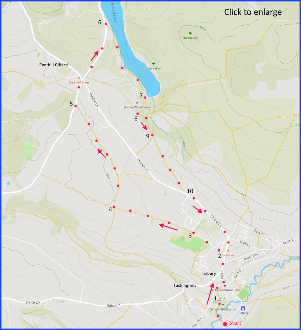
(Route from map points + metres to next point)
Start: (If parking near station): Before (south) slipway to station take footpath off Jobbers Lane. to cross river, walking towards church tower and then through churchyard towards a (gated) footpath opposite: 257m
1 Head up this path. Then left on Paradise Meadow to junction with High Street (at Coop). Head uphill to left turn into Weaveland Rd just before Boot Inn opposite (by bus stop and a thatched house): 470m
2 Walk up this lane until reaching swimming pool: 380m
3 Take right path at 2 black bollards (and waste bin). Bear left at once. To continue straight on fenced/hedged path towards an intersection of paths: 780m
4 Take path sharp right and follow fields until meeting road: 1km
5 Turn right on road. Pass Inn at junction. Continue on road until it reaches lakeside path entrance by car pull-in. 820m
6 Walk south (right) on lake path towards end dam. 880m
7 Join gravel path but quickly right onto footpath towards farm (closeup here): 200m
8 Just after farm pick up field path on left, and south towards wooded area: 200m
9 At this point there is a cut to Hindon Lane – but the lane has little paving so that walking on may be better: 600m
10 Walk Hindon Lane, pass Boot Inn again, and return to start: 1.5km
The pictures below are in the order things were seen on this walk. Clicking on any one will enlarge it (and the slideshow)


![[A]](https://wiltshirewalks.com/wp-content/uploads/2022/05/A-1.jpg)
![[B]](https://wiltshirewalks.com/wp-content/uploads/2022/05/B-1.jpg)
![[C]](https://wiltshirewalks.com/wp-content/uploads/2022/05/C-1.jpg)
![[D]](https://wiltshirewalks.com/wp-content/uploads/2022/05/D-1.jpg)
![[E]](https://wiltshirewalks.com/wp-content/uploads/2022/05/E-1.jpg)
![[F]](https://wiltshirewalks.com/wp-content/uploads/2022/05/F-1.jpg)
![[G]](https://wiltshirewalks.com/wp-content/uploads/2022/05/G-1.jpg)
![[I]](https://wiltshirewalks.com/wp-content/uploads/2022/05/I.jpg)
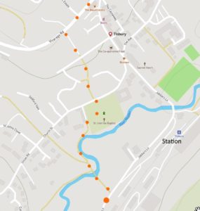
This is a small town on the edge of the large Fonthill Estate (through which this walk meanders). It has a pleasing layout in which a steep through street tumbles gracefully down to the main square – well served by discrete but distinctive shops. There is an agreeable rhythm to the buildings lining the street, and the lanes that join. Wandering the town beyond the limits of the route described here would be well rewarded. For example, diverting up Court Street (towards end) leads to the largest Tithe Barn in England. The route from the lake down to Hindon Lane is an official footpath but this closeup may help.
Tisbury past
There was once a stone circle at a point near the end of this walk. But the better-understood early history of this community is dominated by its relationship to nearby Shaftesbury Abbey – founded by Alfred the Great in 866 and the first establshed for women in England. A pre-existing Tisbury monastary was passed to Shaftesbury around the 10th century. Prosperity later developed in the 13th century from the quarries here. In particular, Tisbury stone was taken for the building of Salisbury Cathedral. Quarrying declined through the Black Death but recovered to a point in the 19th century when there weree 40 active quarries. There was also wool here, linked to a local cloth industry.
The walk
The route starts at the station. It might seem puzzling that an apparently sleepy market town should have such a buoyant station. The fact that there are half-hourly direct trains to Waterloo (2 hours) hints that this place may be quite prosperous (how many towns have a tearoom consciously designed in the style of Cecil Beaton?). One suspects a few art dealers and City folk might be commuters (or weekend visitors) on the West of England Main Line.
The walk crosses the River Nadder [A] and enters the churchyard of St John’s parish church – renowned for its 31-feet circumference Yew tree. Its probably between 1000 and 2000 years old (and not the 4000 claimed by the church) and so qualifies as an “ancient” tree – the system favoured by tree enthusiasts. Pevsner declares that the church itself is the largest in this part of the county. It once had a spire on the crossing tower – but this collapsed in 1762 (cf. Steeple Ashton). There is a pleasant row of late 17th century houses to admire at the north of the churchyard [B].
The steep street climb goes passed Gaston Manor (opposite the unexpected high street filling station and before the left turn off). This is a late 14th century building (albeit rebuilt substantially in the 16th and 17th century). Its not a “Manor” at all. That title is an invention of Estate Agents – ever looking for ways to make a property seem more valuable. Previously it was “Gaston Farmhouse” and had probably been once occupied by nuns. Walk beyond the Weavenland Road left turn and you find the house of Tisbury’s most distinguished former residents. Rudyard Kipling’s parents lived here (at The Gables) and are burried at the parish church. In the 1890s, their son rented a property to be near them and Kim was partly written in Tisbury.
The route turns off into Weaveland Road. Before the field path [C] starts there is the Nadder Centre which includes an open-air heated swimming pool – claimed to be unique in Wiltshire. (Such claims! I thought there was at least one in Melksham “the Blue Pool”?). The route is fairly flat [D] until passing the Beckford Arms (fine pub but don’t expect a game of darts) after which its all Fonthill Estate. The last section of the field paths is public way but a closeup map may help. Finally, to enter Duck Road. That is a point where a detour might be tempting. Drifting east on Court Street and Chillmark Road allows a sighting of Place Farm – a mix of medieval buildings once a grange of Shaftesbury Abbey. Arguably the pride of Tisbury. The 200-foot tithe barn monster is said to the largest in England (but, surprisingly, not the longest). Historic England declares that Place Farm is “one of the finest surviving groups of monastic grange buildings in England”.
Local aristocracy
The barn is let to Messum’s – art dealers – by the Fontill estate. The 9000-acre estate was most recently (1972) acquired by the Conservative politician and peer John Morrison – otherwise Baron Margadale of Islay. Morrison had gained the very last hereditary English peerage to be created (motto: “Prudence before any thought of reward”). The Morrison Baronetcy prudently own a large proportion of Islay in Scotland (73,000 acres). Regarding the present estate house, the website declares “The gardens are a haven for the 3rd Lord Margadale of Islay and his family.” Sadly, the haven is only open to others on about three days in the year.
The notorious 19th century owner of Fonthill, William Beckford, was a vastly rich but somewhat reclusive individual. However, he was also said to enjoy the excitement of social gatherings. When the Honourable Nancy Morrison recently threw a lavish party on the estate, locals for miles around were kept awake until 8 am. Residents observed that they might risk being seen as modern Serfs. Many traditions remain protected here.
Just to congratulate you on a wonderfully detailed description – lots of effort!
thanks for the feedback