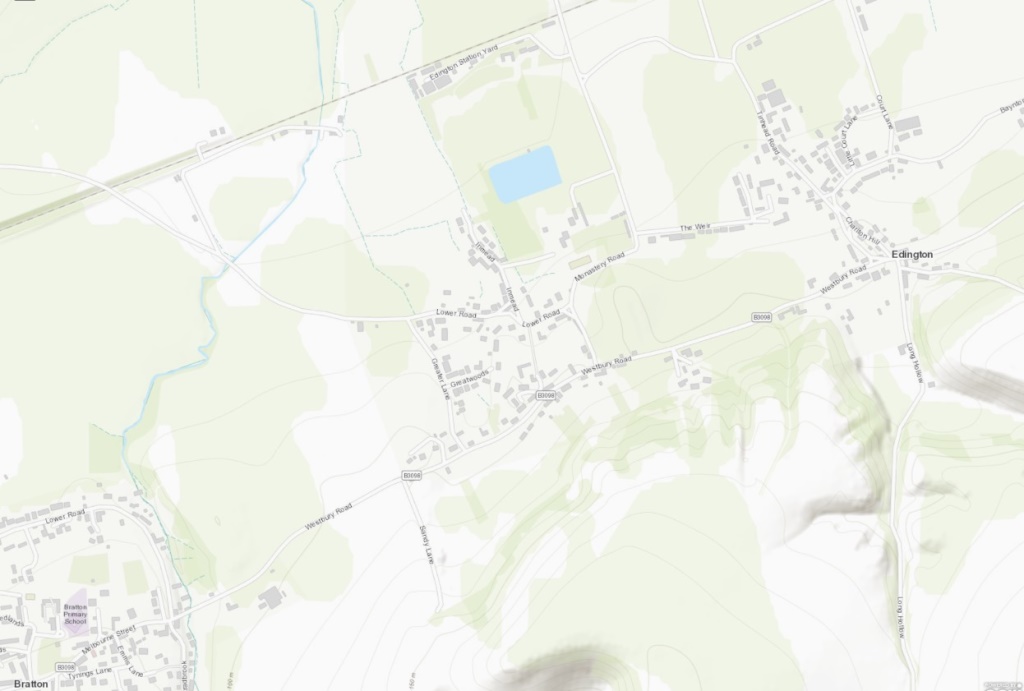
A 4.5 mile sausage walk between two villages. One stile and some steep (but clear) wood paths half way. (Click map to enlarge / Water is blue, wooded green, contour lines show slopes. Click here for an aerial view. Click here to download/print page PDF). (There is a GPX route option here for phone/tablet download. But only follow this link after watching this GPX help video). Friendly warning: all files relating to walks are published here in good faith but on the understanding that users must be responsible for their own safety and wellbeing.

Start Walk due west passed church on high verge, turn corner left – find main road has junction on right. 170m
1: Cross the main road to this junction and walk along ‘The Weir’. Avoid left turn. But shortly lane veers lefta again, but here a footpath begins in front of you. 320m
2: Take that footpath as it continues westwards. Cross Tinhead Road and veer slightly left (downhill) to pick up Baynton Way until Y-junction at a white house. 325m
3: Stay on Baynton Way which continues on the right fork here. Eventually it becomes a footpath that runs across a number of gate-access fields until meeting road junction. 1.5km
4: Head left on meeting this road into Coulston and follow it until signposted fork. 400m
5: At this point take the right fork signposted “the church” until you reach church. 170m
6: By the church noticeboard, take the footpath on the right towards that church building. A gate on the path alongside leads to a footpath along the edge of the deer park. Enter. 200m
7: It becomes a lane. Follow it down to the Park main gates. 250m
8: Cross the main road and head up a steep incline, keeping a ‘1 o’clock’ line of walking. It becomes wooded half way and very steep (if you don’t fancy the field route, then take the lane marked as blue dots on the map – although reaching this via the cross-park footpath at 7 may be safer than the main road). Continue until reaching open field. 450m
9: At this summit veer right towards a stile. Walk up the left side of the field beyond it following line of tree to lane. 230m
10: Turn right onto Salisbury Hollow Byway and follow it until it links with the the main (Westbury) road. 1.7km
11: Joining the main road; take the footpath home just beyond the Three Daggers pub. This repeats the very first part of the walk back to the church. 1km
The pictures below are in the order things were seen on this walk. Clicking on any one will enlarge it (and the slideshow)

![[A]](https://wiltshirewalks.com/wp-content/uploads/2022/07/EdingtonC.jpg)
![[B]](https://wiltshirewalks.com/wp-content/uploads/2022/07/EdingtonD.jpg)
![[C]](https://wiltshirewalks.com/wp-content/uploads/2022/07/EdingtonE.jpg)
![[D]](https://wiltshirewalks.com/wp-content/uploads/2022/07/EdingtonF.jpg)
![[E]](https://wiltshirewalks.com/wp-content/uploads/2022/07/EdingtonG.jpg)
![[F]](https://wiltshirewalks.com/wp-content/uploads/2022/07/EdingtonH.jpg)
![[G]](https://wiltshirewalks.com/wp-content/uploads/2022/07/EdingtonI.jpg)
![[H]](https://wiltshirewalks.com/wp-content/uploads/2022/07/EdingtonJ.jpg)
![[I]](https://wiltshirewalks.com/wp-content/uploads/2022/07/EdingtonK.jpg)
The walk
There is parking around the church area. (But avoid using the park next to the church when there is a notice out saying “for church only” – as this may be service time) Your reward for taking this walk resides in treading ground of great historical significance. The fame of the village rests not so much on its village identity as in it being a particular piece of land: the site of a very important battle. The route is along residential lanes at first but subsequently becomes very rural – as it passes through a hamlet, a deer park and substantial hill climb. That climb is steep and the wooded area at its summit requires careful attention to bearings. Although only marked footpaths are taken here.
Edington village
The village today – that which later emerged at this site – is not particularly interesting (excepting its church). Perhaps because it has no obvious centre (a little disconcerting in a Wiltshire village). Even the church – prominent enough – seems set apart from any housing. What housing there is roughly distributed around the old Bath to Salisbury turnpike (B3098), or scattered along ‘The Weir’ lane. Edington’s railway station, also disconnectedly north of the settlement, was closed in 1952. To the south, the chalk scarp of Salisbury plain reaches over 700ft at Tinhead Hill (included in this walk and the site of a prehistoric long barrow). Tinhead was once a village separate to Edington but now exists only as set of street and landscape names.
The Battle
Most of us know little of the period between the exit of the Romans (say, 500AD) and the Norman conquest. Although what we may know is that the land now called ‘England’ had been ravaged and occupied by Scandinavian invaders. One event that stopped this territory becoming ‘Daneland’, rather than ‘England’, was the Battle of Edington (or Ethandun). That battle took place in the present area: where King Alfred defeated the Danes under Guthram in 878. (You can find some visual context-building here, if you want more. While Melvyn Bragg (and customary three friends) offer a good discussion of the battle and its impact here.)
Historians declare that the significance of the battle outcome was in how it empowered Alfred to extend his existing territory of Wessex to create a unified area that was – largely – what we now call ‘England’. But of special importance was his imagination in doing this. It involved converting his Danish enemy to Christianity, creating something approximating a standing army, forming a network of defensive towns (e.g. Cricklade), and vigorously promoting literacy among his citizens. Thereby Alfred was nominated “the Great”.
Later history of Edington
Edington’s early medieval identity was focussed on Edington Priory, founded in the C14 as a monastery of the Brothers of Penitence (or ‘Bonshommes‘ – simple clothing, simple living etc.). There were no ‘monks’ in the proper sense – just a rector and these ‘brethren’. Originally sited behind the church, there is little left of this today, as most was destroyed by 1539. Post monastery dissolution, the land was granted to Sir Thomas Seymour (brother of Henry’s Jane and fourth husband of Katherine Parr) – although Seymour was later executed and the property reverted to the Crown and thence to William Paulet (Edington’s second pub is the Paulet Arms).
Later in this period, the main business of Edington was some arable and much sheep farming. As with other Wiltshire villages, the processing of wool was a significant source of income – with several mills existing on the minor waterways around this area.
A distinguished Church
The rather austere-looking church of St Mary, St Katherine and All Saints [A] should be visited (or a drone visit is possible here I suppose). Pevsner declares this late 14th century church is “highly important”. Perhaps because it illustrates – in a single building – transition from the ‘decorated’ style of English church design (think graceful curvilinear) to the ‘perpendicular’ (think rectangles). It is strikingly all of the same historical period (except the rather forceful pink/white plaster of the ceiling, which is 17th century), with a rather sombre exterior. But much of interest is inside: for instance, check out the particularly flamboyant canopied monument commemorating local landowner Sir Edward Lewis (1665), with its five kneeling children set between two standing angels. Not to mention a third angel, strangely hovering above the resting couple (hopefully with the best of intentions) [B].
The church has a set of bells which you can see being rung in this video (but no ringer looking that happy about it… perhaps its the intense concentration required?) Sadly, few people seem to know about the Edington Festival. This is a once-a-year (August) jewel of church music, largely sung by choirs from English cathedrals and Oxford or Cambridge colleges. If you like your singing located in the theatre of the liturgy, then this should not be missed.
Coulston and Tinhead Hill
The walk turns round on the tiny settlement (hamlet? village?) of Coulston. No shop, no pub, but 60 or so houses and the church of St Thomas Beckett [F} which Pevsner observes is “battered in a picturesque way”. A flat grave at the east end of the churchyard is that of poor Francis Savill Kent (aged 4) knife-murdered (1860) by his sister (aged 16). Much debated at the time: the sister’s confession led to 20 years in prison (after which she changed her name and lived to be 100). However the case is controversial: it involves evidence prompted by a sacramental confession, while some authors suggest she was covering for her brother. Both children had resented their father’s re-marriage – and the hapless son that had issued from it.
You might look inside the church for a moment of spiritual inspiration, in preparation for tackling the steep slope of Tinhead Hill [H]. But before you get to the foot of that climb, pass through Coulston deer park with its sizeable herd of anxious-looking beasts. All that you behold belongs to the resident family of Baynton manor – a distinguished 18th century house with three reception rooms, a panelled hall, long gallery, study, six principal bedrooms, six secondary bedrooms, eight bathrooms and 16 acres of garden (just where does such private wealth come from, one wonders)