A 3.5 mile circular walk around Heytesbury – a route for walking the River Wylye valley on field paths and lanes. Elegant village. Two churches. Silence. (Click map to enlarge. Click here for an aerial view). Click here to download/print PDF. (There is a GPX route option here for phone/tablet download. But only follow this link after watching this GPX help video). Friendly warning: all files relating to walks are published here in good faith but on the understanding that users must be responsible for their own safety and wellbeing.

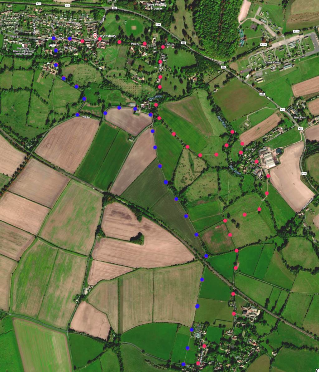
(Route from map points + metres to next point)
Start: At cross roads (just west of former Angel Inn) continue unto Park street. Walk forward until Park Lane on your right [A]. 780m
1: Walk towards River Wylye and cross. 450m
2: (closeup map here) Immediately follow footpath sign on left, and shortly cross stream continuing forward (don’t take right path). In 50 metres take the left path at a Y-fork. Follow path at field edge until boundary. Walk diagonally across next field and follow path through wooded area alongside stream. Find River Wylye in wooded area (closeup here). 500m
3: Cross River Wylye. Turn right at path junction and follow to church where paths cross. 200, Continue on this path [E] until gate and take marked footpath past cattle pens to Y-fork in paths. 420m
4: At this fork take the right stone path and follow, crossing stream until reaching a path X-junction
5: Take the left hedged path and follow until it becomes a paved lane leading to the Dove Inn. 1km
6: Take up slope beyond the Inn and find field path on right. 90m
7: Walk forward on the edge of two fields towards railway bridge. 620m
8: Pass under railway bridge and continue straight path until reaching Mill Lane. 920m
9: Join Mill Lane and follow it to junction with Tytherington Road. Right turn back to village. 1km
The pictures below are in the order things were seen on this walk. Clicking on any one will enlarge it (and the slideshow)
![[A]](https://wiltshirewalks.com/wp-content/uploads/2022/08/heytesbury_01.jpg)
![[B]](https://wiltshirewalks.com/wp-content/uploads/2022/08/heytesbury_02.jpg)
![[C]](https://wiltshirewalks.com/wp-content/uploads/2022/08/heytesbury_03.jpg)
![[D]](https://wiltshirewalks.com/wp-content/uploads/2022/08/heytesbury_04.jpg)
![[E]](https://wiltshirewalks.com/wp-content/uploads/2022/08/heytesbury_05.jpg)
![[F]](https://wiltshirewalks.com/wp-content/uploads/2022/08/heytesbury_06.jpg)
![[G]](https://wiltshirewalks.com/wp-content/uploads/2022/08/heytesbury_07.jpg)
![[H]](https://wiltshirewalks.com/wp-content/uploads/2022/08/heytesbury_09.jpg)
![[I]](https://wiltshirewalks.com/wp-content/uploads/2022/08/heytesbury_10.jpg)
This route heads outward from an attractive village comfortably composed around a Georgian High Street. The village has a unified, intact feel, perhaps because it was largely re-built at one time – after much of it burned down in 1765. Prominent on the High Street (and among the re-built dwellings) is the elegant Hospital of St John – founded in 1470 by the Hungerford family to support a chaplain, twelve poor men and one poor woman. [Just one woman? OK, median life span of women was 5 years shorter than men then (unlike today) but at age 44 years – and beyond – there was surely plenty of female poverty? But the Lady Hungerford must have had her reasons.]
Today, Heytesbury’s male and female, rich and poor seem to have cultivated a good community spirit, including support for an active football club (founded in 1900). However, don’t be misled by the street called “Little London”: the village seems to have just one shop. In 1830 William Cobbett in his Rural Rides commented: “this place… which was formerly a considerable town, is now but a very miserable affair”. See what you think.
The walk
This area is a good choice for walking. Indeed it contributes one part of a favourite route for many serious walkers: namely, the 136-mile Wessex Ridgeway that runs right through the county. The present walk may touch onto this – but it’s really hard to find sources that map out the Ridgeway route so one can judge the points of such overlap (why are so many website walkers more interested in photographing a route (yes, charming) rather than helping others find and navigate it). Unsurprisingly, the water worked in other ways: there is a 19th century mill just round the corner (from your route) on Mill Lane.
The key to the pleasure of this route is its adjacencies to the River Wylye (tributary of the Hampshire Avon). This ‘Middle’ Wylye was formerly recruited for managed irrigation. Water would flow from it over the meadows, thereby nurturing early (Spring) grass for hungry cattle. This made the resultingly rich landscape much admired by Victorian commentators (Cobbett – ‘Rural Rides’ etc.) And it remains a fine site to enjoy when walking today, not least because of the legacy from this water meadow history.
Heytesbury House
This is the domestic building for which the village is best known. Sadly, the closest you will get is the gates on your left as you walk down Park Street. (The by-pass cut right through the drive in 1985.) Briefly, William the Conqueror had a hunting lodge on this site and, later, his grand daughter Matilda lived there while she was trying to get the throne off King Stephen. The Hungerfords took it over shortly after and then the Ashe family from the 17th century. Destroyed by fire in 1766 – architect of Bath, John Wood, re-modelled it in 1784.
From 1933 until 1967 it was the final home of Siegfried Sassoon the distinguished Great War poet. Although respected as a war hero, during the war he campaigned vigorously against prolonging it. Perhaps his controversial status encouraged a more private lifestyle: one that had him called the “Hermit of Heytesbury” (see the hermit at home here). Nevertheless he drew eminent celebrities from the London cultural set during his life in this house. Some of this has been revived in a biographical movie. It’s sad that the house can’t be visited but in such situations (£2.5m most recent asking price)
Knook
Its Celtic meaning ‘hillock’. Some say. Tiny village with a big 16th century manor house pleasantly set on the river [E]. The church [F] here is early Norman but significantly restored in the 19th century. It’s most discussed feature is the Norman carving on the south wall tympanum (area within the doorway pediment). Then to the east of your walk (not visible without a detour) is the much-excavated Knook Down. This is thought to be the site of an early English settlement and, later, a Roman summer camp. The hillfort and its surrounds have revealed many relics from the neolithic period onward. The current village of Knook is thought to indicate a Saxon period ‘coming down’ of earlier settlements from that higher and fortified ground.
After Knook – and at the base of this oval walk – you pass through the very small settlement (hamlet?) of Corton – where even the walls seem to be thatched. If its a very warm day then you may be very pleased to find the Dove Inn (although may now be closed). At first sight its extensive accommodation block renders it rather like one of those motels you encounter in affluent North America. Don’t be detoured: sit outside and take doubtless welcome cold refreshment.
Haytesbury church
The walk returns to High Street at the church of St. Peter and St. Paul. Worth a look despite Pevsner’s judgement: “a large and impressive church….but an over-restored one… which makes it externally more rewarding from a distance than from near by and internally disappointing in spite of its undeniable grandeur”. Most of it dates from 12th and 13th century although it is dominated by its large square Norman tower.
The final Heytesbury structure to note is the octagonal 18th century Blind House (or Lock-up if you will) on the left side of the road and set into a garden wall. A (close-able) grill in the oak door potentially plunges the hapless victim into total darkness. Inside they would have a wooden bench (with a rusty chain at one end of it). If this bleak place feels an unwelcome jolt away from the Georgian charm of pastoral Wylye – head on down to the agreeable Red Lion Inn for some twentieth century recover (possibly now closed)
Thanks for a great website – super useful to have access to a range of circular local walks 🙂 Tried this Heytesbury walk yesterday with the kids, and although we went slightly wrong based on the instructions we got back on track with the GPX viewer file. A lovely level walk, with nice views and minimal roads, great for children.
Good and, yes, i think its a bit tricky around point 3 on the map – depends a bit on how the field and hedgerows have been maintained. But glad you used the GPS – its always a saver
It may be a good idea to mention the Red Lion Inn Heytesbury as the start point, as the Angel has now closed. The Red Lion has been under new management for the past few years. It offers two real ales, an extensive wine list to go with a full lunchtime and evening menu. It also has a very large beer garden.
noted – and sounds a very good pub. thanks