SN14 8RP This is a 2 mile walk around Ford starting at tiny village, taking field paths circling through Slaughterford. Click map to enlarge. Water is blue, wooded green, contour lines show slopes. Click here for arial view. Click here to download/print PDF. (There is a GPX route option here for phone/tablet download. But only follow this link after watching this GPX help video). Friendly warning: all files relating to walks are published here on good faith but on the understanding that users must be responsible for their own safety and wellbeing.
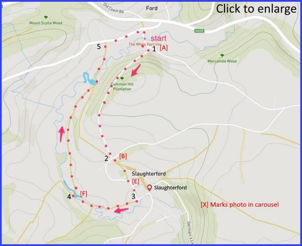
(Routes to take from map points + metres to next point)
Just beyond the White Hart car park, cross the bridge and take the path on fhe right, labelled “single track road”.
1: Pass through a wood that becomes a field drack until meeting a T-junction. 750m
2 Cross into field footpath straight ahead and walk towards St Nicholas church [D]. Join the road beyond the church and walk downhill past a wall post box and some cottages (picture E). On the next corner find a gate/footpath and enter. 270m
3: Follow a footpath with the river alongside until a bridge [F]. 500m
4: Continue path back to main road. 650m
5: Walking carefully (!) to the right until returning to the very agreeable White Hart pub [A]. 500m
The pictures below are in the order things were seen on this walk. Clicking on any one will enlarge it (and the slideshow)
![[A]](https://wiltshirewalks.com/wp-content/uploads/2021/10/01ford.jpg)
![[B]](https://wiltshirewalks.com/wp-content/uploads/2021/10/02ford.jpg)
![[C]](https://wiltshirewalks.com/wp-content/uploads/2021/10/03ford.jpg)
![[D]](https://wiltshirewalks.com/wp-content/uploads/2021/10/04ford.jpg)
![[E]](https://wiltshirewalks.com/wp-content/uploads/2021/10/05ford.jpg)
![[F]](https://wiltshirewalks.com/wp-content/uploads/2021/10/06ford.jpg)
![[G]](https://wiltshirewalks.com/wp-content/uploads/2021/10/07ford.jpg)
![[H]](https://wiltshirewalks.com/wp-content/uploads/2021/10/08ford.jpg)
![[I]](https://wiltshirewalks.com/wp-content/uploads/2021/10/09ford.jpg)
The walk
The first section of the walk is a very pleasant pathway through woods. These lead to an open field and thereby access in the village of Slaughterford, passing by its church. The 17th century Manor Farm is to your left before you enter the church field. After walking through Slaughterford village, a field path is followed, leading back to the main road, and starting point. However, do be careful on this road section: it’s not that it is so busy but traffic seems to move at great speed and there is scarce verge.
Ford and Slaughterford
Ford is a very small settlement with not much of obvious note, although it has a very good pub. The river ByBrook is prominent. This is a river that played a significant role in servicing the North Wiltshire wool trade – through supporting a number of Fulling mills. It runs down to join the Avon about 10 miles away at Bathford.
In the village of Slaughterford is St Nicholas church [D]. Pevsner has little to say about it (and probably it will be locked) but it is nicely positioned. Cromwell’s men passed through Slaughterford on their way to Ireland. In their Puritan excitement they went beyond a bit of the usual plunder and idol-smashing: they actually destroyed the whole building. It was not until 1823 that the present St Nicholas was constructed to replace it. In the meantime, the congregation had to trek over to Biddestone to do their worshipping (and where a gallery across the west end is said to have been added in 1712 to accommodate them – suitably separated from the not-very-welcoming local congregation).
The name ‘Slaughterford’ derives from nothing very gruesome – such as might be associated with ancient battles. Even through it is claimed that in 879 King Alfred defeated the Danes here (many authorities now say it was actually at Edington – nevertheless, the other side of map point 3 is still known as ‘Bloody Meadow’). The village name is thought to mean ‘sloe-tree ford’.
A history of paper
Power from the ByBrook was once an important wheel turning the industry of these villages. There were three mills in Slaughterford in the 16th century with cloth produced here until early in the 19th. But in addition there was the paper making here: also water dependent. Paper was once a significant industry in North West Wiltshire – and largely thanks to the clear water of the ByBrook.
So, shortly after you leave the village at map point 3 you pass the area where there are signs that once there stood here the Rags paper mill. ‘Stuff’ was produced from torn and boiled cloth rags (today this would be a ‘Green Industry’). All achieved thanks to a 9 ft water wheel supplemented by a gas engine. After which this torn and boiled ‘stuff’ was transported in elm vats on bogies to a ‘chaps’ mill by the bridge, there to make the finished product. Slaughterford was a major producer of paper from 1790. That is until mill owner Charles Ward was found guilty of producing unstamped paper and the sheriff confiscated all his goods. However, by 1827 the mill was back to paper making. Finally it was closed under W J Dowding in 1994 and the machinery was transported to South Africa.
In the early 2000’s a developer purchased the Paper Mill to convert the site into executive housing. Villagers fought to call a stop to this idea, and they eventually succeeded. The developers finally put the Mill up for sale again. It was purchased by some villagers and is now used for local small artisan businesses, including cider making.
The author Katherine Webb has passionately written about this area, where apparently she lives – indeed, a novel set around Slaughterford is promised. There is already some mention of the place in her story The Misbegotten. If you browse in and around this village (and the walk is short after all) you may take the chance to explore some of the romantic ruins still visible as echoes of this milling history. Notice the wall post box from the reign of Edward VII by the cottages (pic E) – now a rarity.